
Today we returned to the Saguaro National Park to see: petroglyphs from ages ago, the mines dug out around the turn of the century and the work that the CCC did in the 30’s. Let’s start chronologically with the petroglyphs.
There are actually 2 major places to see them: the wash next to the trail we took several days ago up to Mt Wasson and at Signal Hill. Hmmm, maybe I should say that there are 2 places where there are petroglyphs that the park Rangers publicize allow the public to see. I’m sure that the park rangers probably know of many other places but these are not publicized and not on major trails. And, that’s fine, we’ve got to protect them. Often we see petroglyphs that have been destroyed or marred by modern day visitors. sometimes we see a rock that has new surfaces on it - someone has probably chipped off the parts with the petroglyphs. Or, someone takes a lot of time to chip their name into the rocks. Or they hurriedly spray paint their name. Thanks, people - ruining it for the rest of us.
The oldest known rock art are cave paintings found in Europe, Australia, Asia and Africa that date from the Upper Paleolithic period, 35,000 to 40,000 years ago.
Most southwestern rock art is not that old but it pre-dates modern written history and had it's origins hundreds, perhaps thousands, of years ago, created by the people of this region. Most of the rock art found in Saguaro National Park was created by the prehistoric Hohokam and is in the form of petroglyphs. These are created by etching, pecking or scraping designs into the dark patina found on the surface of sandstone and other rocks.
Both representational and abstract designs can be seen in Hohokam petroglyphs. Representational images are often animals, humans and astrological objects.

Abstract designs take many forms, including spirals and squiggly lines.

And, we saw all of these in the park today. As you know, pictographs are pictures painted on rocks whereas petroglyphs are usually pecked into rocks using two rocks, one to make the design and one to hammer it to make it deeper. Petroglyphs are pecked into what is called Desert Patins, a blackened surface on whiter rocks. When this black surface is removed by the stone, the white surface remains. Now, there is a good scientific explanation of what this black surface is which involves iron and manganese from the atmosphere adhering to the rock with lichens and bacteria. They get darker and darker over time until they make a good surface for petroglyphs.

What do all these petroglyphs mean? Do they tell a story? Are the religious symbols? Are they records of events? Who knows? There is a lot of speculation but no one knows for sure. We enjoy seeing them in our hikes and knowing that others have been here before us, living their lives, their joys, their sorrows, their loves, their families. Close your eyes and imagine an ancient one telling his or her story by pecking with rocks on the blackened surface of the rocks around you.
We parked and headed up a wash towards the Mam-a-gah picnic area. It’s a wash with sides so there was water and dry land to live on here. We knew there were petroglyphs around but not where. We found these metates, where someone had ground corn or seeds into flour.

But had to get much further up into the wash to find the petroglyphs. Our clue was: no desert patina around here.

We had to look closely to find these.

And, even more closely to see these at the top of the wash. What in the world is the dotted square for?
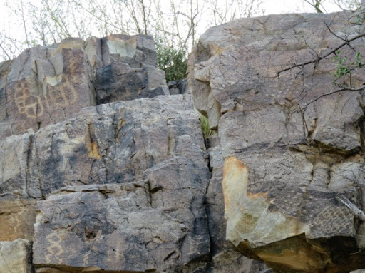
Gary climbed up some rocks to get closer to some of the petroglyphs.

There are a lot here. Squiggly lines off to the right, what looks like a tree or a centipede in the middle and a large tic tac toe square off to the left.

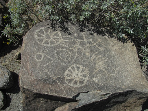
But we found the most petroglyphs at Signal Hill in the northwest corner of the park. Here there were quite a few people circling around checking out the petroglyphs. Signal Hill is a pretty distinct hill, 200’ in diameter at the bottom and 40’ high. There are over 200 petroglyphs many of which can be viewed from the trail that the Park Service put in.


Looks like they’re trying to cut the pizza evenly here.


Pretty cool to think of all the prehistoric artists working away at their easels, women hollowing out metates to grind their cornmeal, kids running around through the wash, men out hunting for their evening’s meal and people walking through the same sand that we are today. Makes our hike so much more interesting.
‘A day without sunshine is like — night.’
Anonymous
No comments:
Post a Comment