We’ve got to get out of the RV - Gary’s been working too hard on the inverter and the hot water tank and - well, he’s been busy. One of our favorite hikes is up Tom’s Thumb, down East End, and then around and about on several FLAT trails to get back to our car. Tom’s Thumb is a steep uphill with lots of switchbacks, East End is a steep downhill with lots of rocky switchbacks with scree. But the views are delightful, it’s a loop trail so we don’t have to backtrack and there’s a fine bench half way around where we can sit, have lunch and enjoy the silence.
Bagels on the way - I’ve decided that donuts are too sweet. Imagine that. Big changes.
Tom’s Thumb is normally saturated by the locals who use TT as their daily exercise. Up, down, and they’re gone. Me? How many times did I stop on the way up to catch my breath and let my legs rest? Don’t ask. Enough. I hate to have people pass me - of course, as I get older, it happens more and more often. But today, a Thursday, didn’t have many locals and I actually got to pass some others.
A-a-a-a-h-h-h-h. The top. And there’s Tom’s Thumb. Still a bit of a scramble to the rock itself. But, our goal today is down the East End.
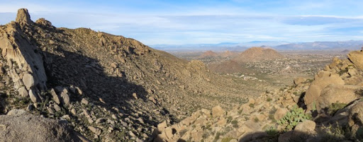
And, down we went. Rocky, steep, lots of scree and switchbacks. But the views - awesome. Looking back up at the saddle.
We’re heading generally down that canyon and somewhere down there is a trail to the left that will take us around this hill and back to the Jeep. And, here’s where the solitude of the trail kicks in. We’ve taken this trail several times and have only met one other person on this trail - a volunteer doing some geological work on the trail. Otherwise, no one - except a befuddled group of hikers without a map and without a plan. When we tell them that the trail only goes down followed by a choice: right back up (yecch) or about 5 miles around the bottom, they quickly turn around and head back down Tom’s Thumb. Gary and I continue.
Lots of rocks around here.
Ah, we’re at bottom and at the bench. Time for lunch. Check out that bench: small rocks embedded in cement - aint’ no one gonna move this bench. But we’re wondering: how in the world did they get it here? We’re 4 miles from where a cement/rock bench could be unloaded by from a truck.
Thank you, Lori and Bud.
Lunch in the solitude of the McDowell Reserve. Oh, I forgot the airplanes. Yep, we’re right under the flight path to the Sky Harbor airport in Phoenix. As soon as one plane flies out of hearing range, another flies in. But with a beauty and grace all their own.
This hare followed us for a while, posing all the way. He’d stop off to our side, pose, then hop hop across the trail in front of us to the other side, pose and then hop back across the trail to the other side to pose again. Look at those ears - and those legs.
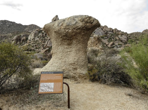
Around the hill and we’re heading back to the Jeep. Cool rocks on this side too. Mushroom rocks.
Xenoliths in these rocks. Xenolith is ancient Greek for strange rock, kinda like ‘Ferguson’ is ancient Scottish for ‘old tired hiker’. Actually this xenolith is a rock that was 'enveloped by molten magma flowing around it and survived when the magma solidified into granite.' At least that's what the plaque said.
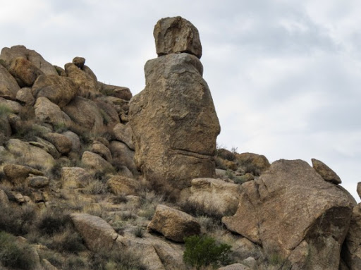
This looks like a wise old man with a top knot and a secret that he’s going to keep. Nothing will open those lips.
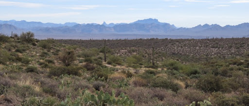
One last view out over the desert towards the mysterious Superstition Mts in the background.
We’re back at the Jeep. Time for clean socks and regular shoes.


No comments:
Post a Comment