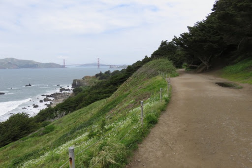
Back to the city for another day of touring. One of the most spectacular walks in San Francisco is the Coastal Trail with its view over the Pacific Ocean for several miles. What a walk ! ! Just us 2 and the waves crashing against the shore. Oh, yeah, the wind which was pretty strong today. My hair was blowing all over and I had zipped up my nylon jacket, buttoned my shirt and pulled my hoodie around my neck.
But, the views - just spectacular - they just make the walk. How many years have these trees stood up to the winds coming in off the Pacific?
Here’s the lighthouse we walked to from Marin Headlands across the bay from where we are now.

I don’t care which way you look, it’s just a glorious view. We’ve walked this cliff walk before and will walk it again. It actually started as a route for the railroads that used to come out here and bring people to the Sutro Baths. Easy to walk but a bit precarious for a train, I would think.
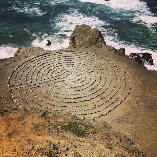
But there are some interesting sights along the Coastal Trail that drew us to it today, things we hadn’t seen before. First was the Labyrinth. On a rocky flat ledge this was public art created by San Francisco Eduardo Aguilera in 2004 having read about other labyrinths in history. He created this as a shrine to ‘peace, love and enlightenment.’ It’s a copy of the 7-circuit Chartres labyrinth made out of stones found in the area but it draws people from all over the world to see it and to enjoy his creation. When we were there, others were also walking down the 213 steps to walk around it, put their offerings in the inner most circle and just to stand in contemplation.
But, you can guess what has happened many times over the years. Vandals destroyed it. Aguilera rebuilt it several times but another person, Colleen Yerge has been rebuilding it lately. She discovered it while walking one day and it has been her talisman ever since. “The only thing I can say is when I get in there and start working on it, everything else disappears,” she said. “I don’t think anything is going through my head. That’s quite a gift to receive.”
One time she got to the labyrinth and every rock had been tossed back into the sea below. What kind of person would get a thrill out of destruction like that?
But, what a gift these two have given to all of us who come to view it and enjoy the time spent on this rocky promontory.
Some have wanted to make it impervious to vandalism but Colleen thinks that would defeat part of the meaning. “It’s a reminder to myself that everything is constantly changing all the time,” Yerge said. “The more I think about it I don’t want to make it permanent, because life isn’t permanent. So I’ll continue to rebuild it.”
This photo is not mine since to take it I would have had to climb up on a higher rock. But I have copied it from Colleen Yerge herself. If not for her, our day wouldn't have been as special.
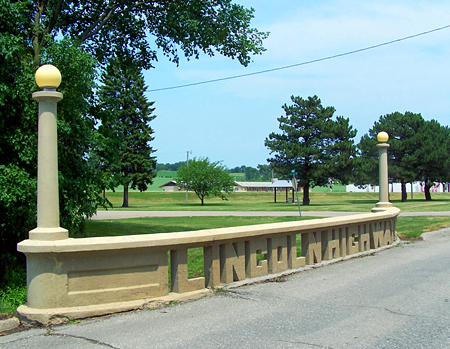
A second thing that we wanted to see was the Lincoln Highway Terminus. Huh? What in the world is that and why in the world would you want to spend time trying to find it? Good question. But, it’s historical, it relates to Iowa and its a quirky tourist goal. And, you know I’m going to tell the story of the Lincoln Highway as we walk along the coastal trail.
In 1912, there were almost no good roads to speak of in the United States. The relatively few miles of improved road were only around towns and cities. A road was "improved" if it was graded; one was lucky to have gravel or brick. Most of the 2.5 million miles of roads were just dirt: bumpy and dusty in dry weather, impassable in wet weather. Worse yet, the roads didn't really lead anywhere. They spread out aimlessly from the center of the settlement. To get from one settlement to another, it was much easier to take the train. No GPS, no street signs, no maps, Columbus had a idea of where he was going than most Americans. But that was all going to change with the invention of the car.

You build cars, you gotta have a road to drive them on. You can’t take a Sunday drive through mud. You can’t go to visit Grandma with no street signs and no maps. Thus, the Lincoln Highway was conceived in 1912 by Carl Fisher, a visionary who also promoted the Indianapolis Speedway and Miami Beach. As the first transcontinental highway in the United States, it crossed 14 states on its way from Times Square in New York, to Lincoln Park in San Francisco. It was dedicated to Abraham Lincoln in 1909 - thus how could anyone not support it? Now, believe me, there were some raw comments made by the states that the highway skipped. Were politics involved? Never. Ha, ha. Bu the engineers designed it to be the most direct way to get from New York to San Francisco.

Markers were placed along the highway and today, a replica of the marker, placed in 2002 by Boy Scout Troop 17 of San Francisco, stands on the southwest corner of the plaza. The Main Street of the Nation proclaims the sign.
Here are 2 pictures of the Lincoln Highway in Tama, IA. The first, from 1915 and the second from 2010.

.
At the end of the Coastal Trail is the Legion of Honor Museum with its fabulous Rodin’s statues, including The Thinker,
gotta stop and admire The Thinker, and in its front yard is the terminus for the Lincoln Highway.
Lastly we hiked over to the Sutro Baths but that is the story for another blog.
But before we headed back to the RV we stopped at Twin Peaks where you can get the best view of the whole city, spread below.


Check out this line of homes switchbacking up the hill.

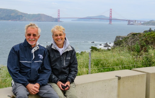
And, now it’s time to head back to the RV, across the Golden Gate Bridge. Beautiful day, awesome sights and we’re not done - we still have that iconic bridge to cross.


No comments:
Post a Comment