Friday, July 31, 2015

Glen, NH - Kancamagus Highway

Potpourri day today: breakfast out, falls, trails and the Kanc.

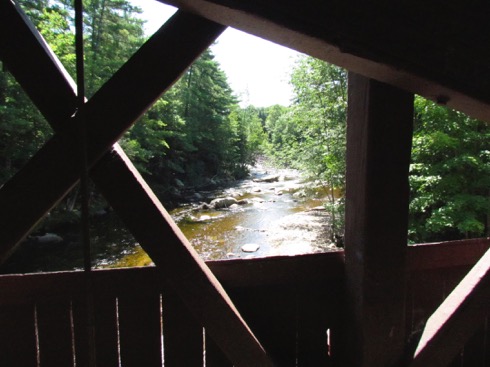
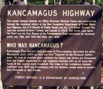
Ah, the Kancamagus Highway. Beautiful scenic highway cutting through the White Mountains with scenic views, waterfalls, covered bridges, rapids to play in, gorges, trails and history. The original route was started in 1837, but it wasn't until 1959 that is was opened and paving completed in 1964. Since 1968, the road has been opened year round except in the most dangerous winter weather. It’s a trip back in time: no gas stations, no fast food, no gift shops, no hotels and - no ice cream. Gas up, bring a picnic lunch and set off through one of the neatest road in the US. If you want a real pleasure, get in line and join the other hordes driving at a snail’s pace during leaf season. You too can become a Leaf Peeper.

And, this is our goal today. But, first, breakfast. We were heading for Peach’s where we ate a few days ago but we were both dissatisfied with the potatoes in the meal and, when we passed the Sunrise Shack and saw a full parking lot, we turned in and were glad we did. Gary had a chourico omelet with home fries and toast and I had my standard: 2 scrambled eggs, home fries and toast. The potatoes were delicious, well seasoned and cooked just right. Gary had cornbread and I had anadama bread. Now, where else can you get such choices? Excellent meal and I wrote a good review in Trip Advisor to counter my review for the other restaurant. They tell me that I am one of their top ‘advisors’ - but, don’t they say this to everyone?

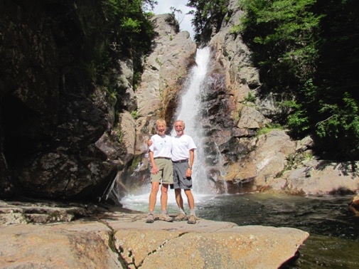
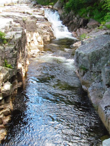
We headed north first to see Glen Falls. Nice moss-covered trail down the side of the gorge, wet from the rains of yesterday (the ones we got caught in), woodsy setting and then the payoff:
GlenEllisFalls-21-2015-07-31-20-47.jpg
GlenEllisFalls-12-2015-07-31-20-47.jpg
Turning south, we drove by all the traffic heading north to Conway - mile upon mile of cars, almost at a standstill on their way north to the wonders of New Hampshire on a sunny day in July. Glad that we were heading in the opposite direction, we hit the Kanc and relaxed.

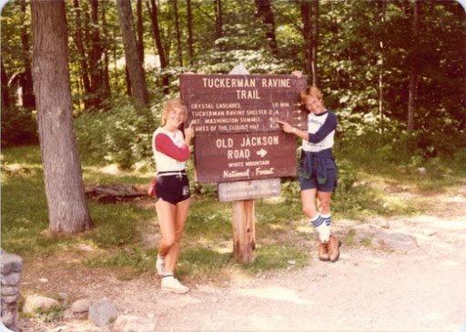
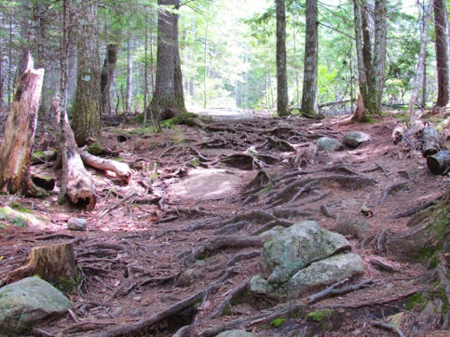
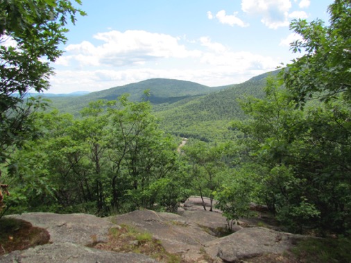
We turned in at Boulder Trail - 3 miles. Again, what do I not understand about trails in New Hampshire? They go up. And up, and up. But look at the neat steps.
CoveredBridge%252526BoulderTrail-7-2015-07-31-20-47.jpg
Up and Up. But the payoff:
CoveredBridge%252526BoulderTrail-6-2015-07-31-20-47.jpg
What view. At, at the view was a family: a baby in a baby backpack, a 3-yr old with the tiniest little hiking boots and 2 parents. Tell me that the 3-yr old hiked up the hill. You betcah. Slowly, but he hiked all except for a few tough sections over boulders.

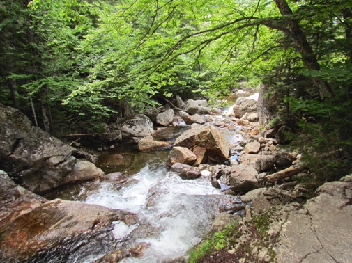
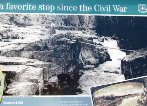
The Lower Falls along the Kancamagus are a popular draw. Looks like lots of others got here before we did. Cool place on a hot day.
LowerFalls-1-2015-07-31-20-47.jpg
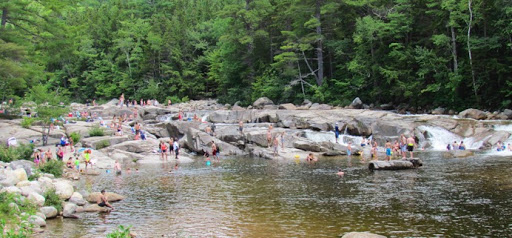
It’s rocky and everyone loves to play around the rocks. There is one section that has been worn smooth by all the water that has passed over it over millions of years. You can slide down one rock into a channel of water that will rush you into a big pool. Lots of fun and we’ve done it. Here’s a young kid having his first slide. You can see his expression.
LowerFalls-4-2015-07-31-20-47.jpg
But, mostly the river is very rocky - except in the spring with all the run-off from the mountains.
CoveredBridge%252526BoulderTrail-17-2015-07-31-20-47.jpg
At the Rocky Gorge, the river narrows. Did we see some dumb kid jumping into it here? Right in front of the sign that said no jumping or entering the water here? Yep, and his mother was watching. Dumb and Dumber.
RockyGorge%252526TrailNearby-16-2015-07-31-20-47.jpg
There is a sturdy bridge crossing it now but here is the bridge that used to span it.
RockyGorge%252526TrailNearby-1-2015-07-31-20-47.jpg
We took the trail around the lake here.
RockyGorge%252526TrailNearby-6-2015-07-31-20-47.jpg
RockyGorge%252526TrailNearby-4-2015-07-31-20-47.jpg
Seems that everyone else wanted to play in the Rocky Gorge, we had the trail to ourselves.
url-2015-07-31-20-47.jpg
Could the day have been any better? Nope. this was great. On the way home we stopped at Attitash which used to be a ski resort but then the owners realized that they were losing a whole season and they added all kinds of summer fun equipment. Back in 1976 or so they added their first summer downhill - a concrete U-shaped trough which you go down it in a special sled. We did this many years ago with my sister-in-law and it was lots of fun - until we got in back of a guy who was terrified of the speed. He had the brake on the whole time. Held us all up. Cripes, speed is the name of the game, sir. Get your hand off the brake. Lead, follow or GET OUT OF THE WAY!!!
AttitashMountainResort-3-2015-07-31-20-47.jpg
Well, they have added lots more to their summer game.
AttitashMountainResort-1-2015-07-31-20-47.jpg
The cement trough is still there. People still line up to come down it.
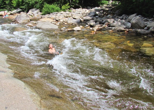
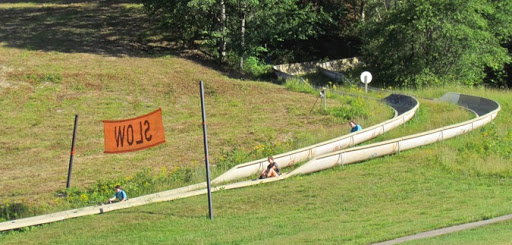
Oops, a woman just got out of her sled and was turning to pick it up when her little kid came down behind her and slammed into it. Luckily no one was hurt. He probably can’t read the 4’ tall sign that reads ‘SLOW.’ Probably not. Interestingly, we heard two kids at different times, bragging about their wounds from the rides and showing off their bandages.

But, it’s 5:30 and its time to head home. Oh, oh - look, an ice cream store. I hear the siren call of Brownie and Kahlua ice cream. Well, here’s the justification: we didn’t bring food or protein bars today and we’ve hiked 1200’ and 5 miles. We deserve this. Whew, a good justification works wonders to salve a conscience.

We leave tomorrow and we have some things to do. Gary likes to unhook all the utilities except the electricity and I wanted to clean off the RV. We’ve been in lots of rain and we have lots of little bits of sand and grit on our basement doors that I’ve wanted to remove for a while. But none of the campgrounds we’ve been recently allow any washing at all. This one says that we could, the forecast is for sun all the way to our next campground, just the words I’ve been waiting for. I sprayed, I wiped down and I’m done.

Ah, 7:30, time for dinner.

And, if you guess that it rains tomorrow, you’ve got prescience. Yep, showers, heavy rain, sprinkles - we drive through all of these tomorrow. Ah - but at least I’ll get clean, new dirt. Shucks.

‘I am a slow walker, but I never walk backwards.’
                Abe Lincoln

Thursday, July 30, 2015

Glen, NH - Singing in the Rain

An administrative day here in the RV. A day in the park. An R&R day. You know, one of those days when Nancy pays bills and writes e-mails, Gary does laundry and whatever maintenance he wants. (I let him have his choice in this - aren’t I generous?) But, then, of course, we want to get our 4 miles in so I found what someone listed as one of the nicest 1 mile hikes in New Hampshire: a wooded trail next to a babbling brook in the NH forest. What can go wrong? Since it’s by a brook, it must be level - just what we’re looking for today. And, it’s only 1 mile, in a mile and out a mile - about what we’re ready for today. The trail is named the Table Mountain Trail. Hmmm - what do I not understand about the word ‘mountain?’ A lot, I guess.
Sounds like a plan, right? We check the weather, oops, a bit of rain coming in, we’d better get over there right away.
Well, you know the plot of this story, before I even write it. Sure enough, we get to the trail, lace up, grab the dry bag and we’re off. We didn’t take our poles - heck, it’s only a mile in and a mile out next to a brook. We met two 65+ yr old guys just finishing the trail, one had at least 25 caribiners hooked onto his belt loop. We asked about poles: one said no, the other said he never hiked without them. Oh, well.
Funny, this trail is about 50’ above the babbling brook. And, we’re still climbing. Every new view shows the trail heading further up. But, what can you not like about a trail that looks like this?
HikingTableMountain-4-2015-07-30-20-13.jpg
HikingTableMountain-3-2015-07-30-20-13.jpg
Well, we did see the babbling brook. And, I’ll have to admit that this trail was a nice one. We keep climbing, through some loose stone and a bit of mud from yesterday’s showers. We looked over our shoulders - hmmm - black clouds, moving in. Just a little bit further. We hit the bare rock which we climbed up. More bare rock.
HikingTableMountain-2-2015-07-30-20-13.jpg
Still the trail curls upward. Not what I expected. But, we’re gonna finish it.
CRACK. OMG - that was the loudest crack of thunder I’ve heard in a while. We rotated 180 degrees and began our downward descent. Gotta get off this bare rock. Without poles through the muddy sections and the loose stone - I have developed my new technique which is an old technique - the snowplow stance down the hill.
CRACK. More thunder - right over our heads.
And it begins to sprinkle lightly. The canopy covers us and we remain mostly dry. It rains harder and we begin to get wet. We’re hurrying down the trail. The rain is pelting down. We’ve got our iPhone, watches, keys and billfolds in our dry bag but we’re getting really wet. (Luckily my shoes are waterproof - and what does waterproof mean when it’s raining like this?)
I hope we can get over those little streams we crossed on the way up. Is the rain filling them up? Will we still find the boulders to jump to or will they be covered? Will we need to wade through them?
Ah, the car. We open the back hatch cover, huddle under it and get out the towels we keep in the car - for just this kind of emergency. We empty the bag, get into the car and take this shot. Two wet chickens.
HikingTableMountainintheRain-5-2015-07-30-20-13.jpg
I don’t think that this is what people mean when the talk about a wet t-shirt.
Hey, it’s all part of the adventure? We got in 5 miles, climbed 1268’ and enjoyed the woodsy trail.
I took this picture after we got down of the radar on our iPhone. That blue dot is us and you can see all the rain that covered us as we were hiking.
HikingTableMountainintheRain-1-2015-07-30-20-13.jpg
A couple, desperate to conceive a child, went to their priest and asked him to pray for them. "I'm going on a sabbatical to Rome," he replied, "and while I'm there, I'll light a candle for you."
When the priest returned three years later, he went to the couple's house and found the wife pregnant, busily attending to two sets of twins. Elated, the priest asked her where her husband was so that he could congratulate him.
"He's gone to Rome, to blow that candle out" came the harried reply.

Wednesday, July 29, 2015

Glen, NH - Used and Abused 2

Gary and I have actually climbed Mt Washington 3 times before we climbed up today. We don’t have a single picture of the first two times but we do have photos of the 3rd time, the time that Gary’s sister, Dawn and her fiance, Tom, climbed up with us.

Here are Tom, Dawn and I standing by what is called ‘undermined snow.’ There have been so many incidents where people have been seriously hurt by this type of unstable snow that they have signs warning of the dangers now. Obviously, we were not concerned when we climbed up. We were obviously climbing in cooler weather than we had when we climbed up today and we were wearing jeans. I can’t imagine hiking in jeans now that I’ve been wearing hiking pants.

8407nn-003-2015-07-29-20-07.jpg

HikingtotheSummitofMtWashington-46-2015-07-29-20-07.jpg

Here’s the obligatory ‘End of the Trail’ photo with Dawn and me. When we all got to the top of the mountain and were sitting in the summit room both Tom and Gary were not feeling good. Whether it was the elevation, the food or whatever, the elected to take the hiker ‘stage’ down the hill. Since the stage dorve to the bottom of the auto road, it ended up about 1 1/2 miles from where the trail head. Tom and Gary got off before the end of the stage ride, hiked back to the trailhead along a crosscountry ski trail. They met us there and took this picture of the tired hikers. I think that by this time we had taken off our jeans and jackets and had changed into something cooler since the weather at the bottom of the mountain was much warmer.

8407nn-002-2015-07-29-20-07.jpg

HikingtotheSummitofMtWashington-1-2015-07-29-20-07.jpg

This time it was I who did not hike down and Gary was the intrepid trekker. Whatever - it is a long hard climb up to the top of Mt Washington, we have done it 4 times and count ourselves lucky to still be able to do this.

I don’t have a clue why we have this picture. I guess Gary wanted a picture of the 3 of us and the sign for Pinkham Notch where the Appalachian Trail goes through and where the trailhead to Mt Washington is.

8407nn-001-2015-07-29-20-07.jpg

Glen, NH - Used and Abused

If Mt Washington is Disney World, then the Tuckerman Ravine Trail is the ‘Pirates of the Caribbean’, its most popular ride. There are no easy trails up to Mt Washington but Tuckerman Ravine is surely the most difficult and tedious. It’s a slow rock scramble over knife-edge sharp, randomly scattered rocks. What it has is the view that one can get by turning around and looking across the valley towards the mountain layers beyond. The higher one gets the better the view.
The trail can be described as a play in 3 Acts. Act 1 is the never-ending curl around the base over rounded rocks, randomly scattered throughout the trail. This is the part I remembered most about our 3 previous scrambles up this peak.
HikingtotheSummitofMtWashington-54-2015-07-29-18-35.jpg
Act 2 is the hand-over-hand pull up Tuckerman’s Ravine. Steeper than the first section with much larger boulders, it is often just a scramble upwards. The trail is in there somewhere. We could see little bits of color from others ahead of us telling us where the trail was.
HikingtotheSummitofMtWashington-49-2015-07-29-18-35.jpg
Here it is from the side.
HikingtotheSummitofMtWashington-41-2015-07-29-18-35.jpg
Act 3 is the boulder field at the top where the trail is so obscure that cairns mark the way.
HikingtotheSummitofMtWashington-31-2015-07-29-18-35.jpg
We started out fresh and dewey eyed. Look at these two eager souls ready to conquer the mountain.
HikingtotheSummitofMtWashington-59-2015-07-29-18-35.jpg
The views were great. Here’s a lake at the bottom of Tuckerman’s. Note how cloudy the summit is - that’s where Mt. Washington is. But it gets clearer as we climb.
HikingtotheSummitofMtWashington-52-2015-07-29-18-35.jpg
We found some snow that had not melted yet. The rule is to not get under or climb up this since it might collapse. But the waterfall is pretty cool too. It looks as if the intrepid hiker is looking a little more harried. I’m about 2/3 up.
HikingtotheSummitofMtWashington-46-2015-07-29-18-35.jpg
The views just kept getting better and better but the haze hung in there.
HikingtotheSummitofMtWashington-42-2015-07-29-18-35.jpg
We got to the top of the Ravine and kept going.
HikingtotheSummitofMtWashington-37-2015-07-29-18-35.jpg
HikingMtWashington-4-2015-07-29-18-35.jpg
Right about here an 11-yr old kid passed me singing at the top of his lungs his own tune and words: ‘The Top is Right up There’. ‘You show me’, I said and he did - he bounced up the rock like a billy goat and left this old woman in awe. Maybe I won’t take his bounding route but I found my own route which I can plod up and, though it ain’t pretty, it got me up to the next rock.
Then we neared the top and saw this: all the cars which had brought people up the Mt. Washington Road. Note the guy looking over the side of the rocks saying: ‘What fools would ever climb up this?’ ‘You’re not getting me to do that.’
HikingtotheSummitofMtWashington-28-2015-07-29-18-35.jpg
Lots of people get a ride to the top and hike down. You can tell who they are, they look fresh.
HikingtotheSummitofMtWashington-24-2015-07-29-18-35.jpg
Not only can you drive to the top but you can also take the Cog Railway. I did this many years ago with a woman from Germany who was staying with us for 2 weeks. Kind of like a foreign exchange student program. The angle is interesting and you keep wondering if you’re going to make it.
HikingtotheSummitofMtWashington-13-2015-07-29-18-35.jpg
We were eating our lunch inside the summit house and I had by this time decided that I was not going to hike down. I don’t bound from boulder to boulder too well because my sense of balance is not that great and I would take forever to get down. Right then the 3 ladies at the other end of the table said: ‘Come down with us’ and I quickly said’ ‘yes.’ Gary said that he wanted to hike down.
We rushed over to the tip-top cairn to get our picture taken. We didn’t have time to wait in line since the ladies were leaving shortly so we didn’t get out picture with the sign at the top - like the people in back us are.
HikingtotheSummitofMtWashington-10-2015-07-29-18-35.jpg
And, here’s Gary getting ready to don his pack and head down.
HikingtotheSummitofMtWashington-9-2015-07-29-18-35.jpg
And, he even took a selfie.
HikingMtWashington-1-2015-07-29-18-35.jpg
And, what did I do while he was hiking down? I decided to hike up to meet him. Don’t nominate me for Mensa. Yep, I decided that I hadn’t had enough of hiking, why not hike up again?
I got about 1 1/2 mile along the trail when I saw him. No surprise on his face - he had expected me to do this. We’ve lived together too long.
We met the rain on the way. Just several showers. Enough to scare us into putting cameras, phones and wallets into the dry bag.
We did stop at the Crystal Cascades though.
HikingtotheSummitofMtWashington-3-2015-07-29-18-35.jpg
Here we are at the bottom, tired, haggard, sweaty, hungry, ready to head back to the RV. Do our legs look like rubber?
HikingtotheSummitofMtWashington-1-2015-07-29-18-35.jpg
I knew I would make it up - the only question was ‘When.’ sometimes I would look up to see the end of the trail but it never seemed as if it got any closer. It always seemed the same distance away. How many passed us today? Lots. Out in the desert where we do most of our hiking, few pass us since we can walk fast and balance is not a problem. But here, in the rocks, I’m slow because I don’t feel comfortable jumping from one rock to the next. This requires a good sense of balance, which I don’t have. I need to plan where to put my next foot and planning takes thought. Others just bound.
We’re going to have to expand our repertoire - no more Mt Washington, we need to hike other mountains in New Hampshire. There are 40 mountains of over 4000’ and we keep concentrating on this one - the one which is 6228.
On the other hand, and this is a clue to how my mind works) I’m thinking that if I can climb 5448’ then I can climb the Grand Canyon which is only 5200’ or thereabouts. Am I crazy or what?
Gary’s t-shirt which says ‘The Mountains are calling and I must come’ is going to be supplanted by my t-shirt which says ‘The Oceans are calling and I must come.’ Much easier. No elevation, no struggle, no little kids bounding in front of me singing ‘The top is right up there.’
Obviously I’m older and, as much as I would to deny this, I can’t do what I used to do without effort. I’ve realized that I’ve got limits and that I am not as fast nor as strong as I used to be and that I’ll never get to hike lots of trails and lots of mountains that I would like to. I wish that Gary and I had discovered our love of hiking while we were living in New Hampshire and had abundant opportunities to fulfill our love. The chances were there, the mountains were there but we didn’t hear them call us until we retired and began to climb mountains for fun. We hiked up Mt Washington three times but never explored hiking any other mountains. We were too busy living our lives to look around to see what we liked to do and to then to do it.
Do I regret lost opportunities? I guess I wish we had followed them more. But it is as it is and I can’t change that. All I can do now is to hike where we can and to enjoy all the little things that come with putting ones foot on trails up mountains: the flowers that bloom along the trails, the view from the top, the little frog that hops in front of us, breezes that wander through the trees, the clouds that scuttle across the sky and the and the glory of still being alive and being able to hike.
“Jumping from boulder to boulder and never falling, with a heavy pack, is easier than it sounds; you just can't fall when you get into the rhythm of the dance.”
                                                         Jack Kerouac, The Dharma Bums
5448’ (OMG) 5.5 mi

Tuesday, July 28, 2015

Glen, NH - Covered Bridges and Mt. Washington

We relaxed today, trying to husband out strength for tomorrow. However, that doesn’t mean that we sat inside. Nope, we went into town for breakfast and then drive back by some old covered bridges. Breakfast was a so-so affair. We had read good reviews on Yelp for a place called Peaches which had wonderful lip-smacking good peaches and cream coffee cake. And, I’ll admit that it was everything that the reviews said except that they omitted the whipping cream piled on top. Whoo-eee. We thought this was the cats pajamas.

The breakfast itself wasn’t as good. Or, maybe I should say that the potatoes weren’t as good. I think they had been on the warming grill for too long and they were burnt and crusty at the bottom. Oh, well. It was a beautiful day on their outside dining area and we enjoyed the fresh air.

We drove around to find some old covered bridges across the Swift River in Conway, NH. Orginally built in 1850, it was lifted from its foundation, swung around and sent rapidly down the river into the next covered bridge, the Saco River Bridge, knocking it off its foundations and both bridges ended up down the river. The wood that was salvaged from these two bridges was used to build the new bridge which is pictures below. It is now just a walking bridge since a new steel and concrete bridge ws built in 1974 to replace it.

2CoveredBridges-1-2015-07-28-11-46.jpg

2CoveredBridges-7-2015-07-28-11-46.jpg

We stopped to do a bit of shopping and noticed that in New England, Dunkin’ Donuts stores are inside the Walmarts.

DunkinDonutsInWalmart_MustbeNewEngland-2-2015-07-28-11-46.jpg

There are some great views of the mountains along the highway north and today we could see Mt Washington, our goal for tomorrow, off in the distance. Ironically, we chose Wednesday for our hike because it was supposed to be sunny, clear with no threats of rain. Tuesday was supposed to be hazy with showers. Darn. Here it is Tuesday and the views are superb. Here you can see a few puffy white clouds crowning the tip of the mountain.

HikingtotheSummitofMtWashington-63-2015-07-28-11-46.jpg

HikingtotheSummitofMtWashington-62-2015-07-28-11-46.jpg

Monday, July 27, 2015

Glen, NH - Tuning Up

Guess why we’re in northern NH? Yep, you guessed it. Gary has a t-shirt that says ‘The mountains are calling and I must come’ which encapsulates our goal here. We have other things to do also but hiking is the main one. We started out today heading west to get to Franconia Notch which is also rte 93. Here you an find the Old Man in the Mountains, the Flume, the Basin and some excellent hiking.

Many, many years ago, I had some friends who were backpackers and who asked me if I would like to come with them for a 3-day trip. Being young and dumb and not really knowing what I was saying, I said ‘sure.’ They strapped a huge pack on me, gave me a few poles and pointed me up the hill. Up, and up and up. Neverendingly up. What is the point of this I wondered. Do people do this for fun? This isn’t how we find fun in Iowa. But, I was committed and followed the plans.

Then we got to the top, the summit, the ridgeline. And, I understood. This is what it is all about. There was the world spread below my feet. I could see for miles. Pretty cool for a little Iowa girl. Give me some more. And, they did. We hiked up to Mt. Liberty, Mt Lincoln and Mt. Lafayette. At night, we had to hike down one of these to a hut. Hike down? All that means is that we’ve got to hike back up in the morning. Shucks. We cooked dinner and then retired to the hut. It was ‘U-shaped’ (I think) and had two layers. I slept on the upper layer between one of my friends and someone else - who knows who this person was - but I’m sure it was a guy and that we introduced ourselves to each other. Gotta follow all of Miss Manners rules, even in Appalachain Huts.

Morning brought breakfast, a hike back up to the ridge line and on down the trail. Great fun.

Today, we were going back to that area to hike - just a day hike,though.

Our first stop was at these cascades.

Silver%252526FlumeCascades-5-2015-07-27-20-15.jpg

Silver%252526FlumeCascades-1-2015-07-27-20-15.jpg

Our second stop was at the Mt Washington Hotel. A beautiful hotel in the shadow of Mt. Washington. I got this picture online since today it was too hazy to even see Mt. Washington in the background. (BTW - that’s our goal for Wednesday - no, not the hotel, the mountain.)

url-2015-07-27-20-15.jpg

The UN established the International Monetary Fund here and they had preserved the room where the paperwork was ironed out and signed.

OmniMountWashingtonResort-12-2015-07-27-20-15.jpg

Very nice hotel. Look at this main entryway.

OmniMountWashingtonResort-13-2015-07-27-20-15.jpg

we walked out onto the veranda and could barely see the round top of Mt. Washington in the holes in the clouds. Playing hide and seek.

OmniMountWashingtonResort-16-2015-07-27-20-15.jpg

Next we stopped at the Flume but, since we had seen it twice in the long distance past, we decided to head right for the hike and walked a mile to the trailhead for the Liberty Springs trail.

HikePartofLibertySpringTrail-9-2015-07-27-20-15.jpg

Very nice trail, woodsy, mossy, a cool bridge over the stream tumbling over rocks worn smooth over the ages,

HikePartofLibertySpringTrail-1-2015-07-27-20-15.jpg

two well-placed logs - perfect for sitting on for lunch.

HikePartofLibertySpringTrail-6-2015-07-27-20-15.jpg

We started late since we had done some touring and also didn’t want to go too far since we didn’t want to wear ourselves out on this hike since we were hiking to the top of Mt Washington on Wednesday. Why wear yourself out on the tune-up hike and die on the real hike?

But it was fun. Maybe next time, we’ll finish it.

I’m sure you’ve all heard of the Old Man of the Mountain. Symbol of New Hampshire. On all the license plates. You could even see it on the New Hampshire quarter.

1__%252524%252521%252540%252521__url-2015-07-27-20-15.jpg

We saw it many years ago and were surprised at how small it really was. It was a small clump of rocks on a cliff and you had to be in the right spot with the sky in back of you to see it. But, it was pretty cool. .

Well, it is no longer. It has been a long time in falling and has been held in place with iron rods, steel cables and lots of hope for many years.

DemiseoftheOldManoftheMountain-1-2015-07-27-20-15.jpg

Here’s a more recent picture showing how it was still being worked on and a second picture showing how it looks now.

2__%252524%252521%252540%252521__url-2015-07-27-20-15.jpg

Brian Fowler, President and owner of North American Reserve and Mining, conducted an in-depth study of the Old Man in 1976 when the highway below it was being built and knew it better and anyone. He is now conducting an ‘autopsy’ to determine why it fell. But, his current theory is that it fell in 5 acts.

3__%252524%252521%252540%252521__url-2015-07-27-20-15.jpg

Here’s a great picture from Wikipedia showing the mountain as it is now with what it used to look like superimposed over it.

4__%252524%252521%252540%252521__url-2015-07-27-20-15.jpg

New Hampshire is still mulling over what to do about their license plates and the symbolism that the Old Man implied. But, he’s gone now and we can only see him in pictures.

We took the Kancamangus Hwy back to the RV. Beautiful views and we’ll be back here in a few days.

LandscapeScenes-8-2015-07-27-20-15.jpg

In the far background, hovering over all and hidden by clouds is Mt Washington.

LandscapeScenes-6-2015-07-27-20-15.jpg

The Sabbaday Waterfalls are also along it. Here are the lower falls.

SabbadayFalls-17-2015-07-27-20-15.jpg

and here are the upper falls rocketing over the stone before they turn a right angle, plunge down under the bridge and surge in to the pool at the bottom of the lower falls. Pretty cool: two falls, a right turn and a gorge cut through granite.

SabbadayFalls-14-2015-07-27-20-15.jpg

But there’s lots more and we’ll explore the rest in a few days. One of he great Scenic Hwys in the US. If you ever get to NH, drive this.

This campground has free wi-fi if you sit in the right spot in the picnic center. We’ve seen people toodle over there with their laptops and iPads to get the signals to sent out their e-mails or catch up on news or Skype. But - and this is a neat thing - I can get on the campground wi-fi right where I sit in the RV since the picnic area is right across the field from my window. Poor Gary, he sits on the other side of the RV facing the wrong way and can’t get on at all. Until he realized that if he sat at the same table where I sit, he can get on. I guess that means that he’ll be crowding me on my ‘desk’ now.

Our neighbors have 4 brown town hanging on their line. (This campground is between the Saco and Ellis Rivers and everyone in near or on the water tubing, sitting, swimming, or standing in a circle chatting) I like that - brown towels don’t show the dirt. Cool. On the other hand, we have pac-towels, same color but these don’t need to hang, they dry so fast.


“How fabulous down was for those first minutes! Down, down, down I'd go until down too became impossible and punishing and so relentless that I'd pray for the trail to go back up. Going down, I realized was like taking hold of the loose strand of yarn on a sweater you'd just spent hours knitting and pulling it until the entire sweater unraveled into a pile of string. Hiking the PCT was the maddening effort of knitting that sweater and unraveling it over and over again. As if everything gained was inevitably lost.”


                                                         Cheryl Strayed, Wild: From Lost to Found on the Pacific Crest Trail