
Thus fortified, we were on our way and arrived in the parking lot by 9:30. Uh, oh, they’re painting the bathroom. And, look, over there, they’re cleaning the other bathroom. And I just drank a cup of coffee. Ah, never fear, the cleaning is done. We’re off. Now, the first 1/2 mile of this hike is filled with petroglyphs done by the Hohokum. We’ve taken this hike before but really concentrated on finding the petroglyphs this time and found a bunch.
The ancient Hohokam Indians and possibly other prehistoric peoples before them roamed this area as evidenced by the petroglyphs carved into rocks We enjoyed these artifacts left by the ancient artists. We’re not happy with those modern ‘artists’ who think they need to carve their initials into these petroglyphs and ruin them for others. We try to imagine what life must have been like for these families living in this area long before Phoenix became a city.


The rest of the hike is a beautiful upward climb.


We sat for a while then reshouldered our packs and headed out to the next part of our hike, upwards towards the highpoint of the mountain and then around all these towers and down another trail back to the car.
We found a trail book, signed by many others who had passed this way. Cool mailbox it’s in. This is new - we didn’t see it the last time we took this trail about 2 years ago.

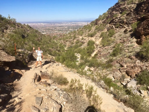
We saw only 2 others on this part of the trail both runners and probably both getting ready for the Summit Run tomorrow. Not a race I’m going to be in. You can sign up for the 4- the 5- or the 7- summit run. You run up to and down from the first summit on your list with your time recorded, then drive over to the next summit, run up and down and then the third summit until you’ve finished all in your category. Here are the trails in the 7-summit run. It’s an all-Phoenix race. Here are the summits in the 7-summit race along with the distance and elevation gain for each one. You can see the totals at the bottom: 21 miles and a gain of 5711’. For a comparison, the most popular trail up from the Colorado River in the Grand Canyon is 5200’ and 7 miles up.
2015 PSC Route Order
PHX7 (1) miles elevation gain
1. Apache Wash Trailhead - Apache Vista 1.2 1982
2. Apache Wash - Ridgeback Overlook 3.77 272
3. Deem Hills 4.74 2035
4. Piestewa Peak 1.2 1162
5. Shaw Butte 4.8 796
6. Lookout Mountain 3.2 498
7. Holbert Trail - South Mountain 2.4 999
_______________________________________________
21.31 5711’
Luckily we hit the trail today since we’d find ourselves a bit crowded tomorrow on Saturday. Actually, these trails are somewhat narrow at times, how can there be racers chugging up and plunging down at the same time? Check out the part of the trail a while back where I am waving. That’s the trail that they would be running up and down.
As we got to the bottom and began to walk back to the car, we saw this quintessential Arizona site:

John Muir
No comments:
Post a Comment