Tuesday, August 4, 2015

Woodstock, VT - Bushwacking

Into Vermont yesterday. Lots of showers. The the rain cleared and we had brilliant sunshine.
DrivingNHtoVermont-6-2015-08-4-21-10.jpg
The next day we went out to explore the Vermont countryside.

How in the world can you get lost on a short hill? Easily, when there are no trail markers, the leaves from countless falls have covered the trail and the trees all look the same. Those darn trees - they all look alike. They all have bark, they all have leaves, they all have roots - yeah, I know, there are many different kinds of trees, but, when you’re in the forest, looking for a trail, they all look alike. Quite frankly, the only kind of tree I want to see is to see one with blue plastic ribbons - the ribbons that marked the trail.

Obviously, I’m just kidding here. I love hiking in the forest and thoroughly enjoyed the hike we had today. But we did get lost and we did have to bushwhack back to a part of the trail we knew. It started pretty innocently, we had a map and it was a popular trail up to the ledges on Mt Tom in Woodstock. Lots of others on the trail, the trail was covered with small stones and lined with logs. But, we just can’t take the usual trail, we have to take some of the trails less used.
HikingMountTom-13-2015-08-4-21-10.jpg
So, we took off on a side trail, the Upper Link Trail, that was really pretty interesting. It’s called the Precipice Trail - and here is why.

There is a railing but the trail is between the metal border and the rocky cliff - right where the roots are.
HikingMountTom-8-2015-08-4-21-10.jpg
HikingMountTom-6-2015-08-4-21-10.jpg
Narrow trail, rebar posts lining it, cables linking the rebar to give us handholds - all with steep rock cliffs on the inside. Oh, boy. Neat trail. Then on the narrowest part of the trail, Gary, heading up, met someone heading down. Oops.

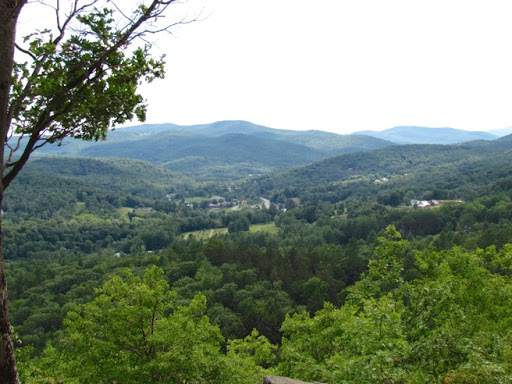
At the top, we met lots of others who had taken the popular way up. Great views over the town of Woodstock and the surrounding wooded hillsides. What a payoff.
HikingMountTom-4-2015-08-4-21-10.jpg
HikingMountTom-2-2015-08-4-21-10.jpg
Now, to get down. Sure don’t want to take the popular way so let’s head over here to the actual summit of Mt. Tom. Again, neat trail winding up the side of the mountain. We got to the summit and then wanted to circle down on the other side to meet up with the Upper Link Trail and head down the way we had come up. The trail was covered with leaves and it was hard to see but there were some blue plastic ribbons on the trees lining the trail. There also were a few yellow paint hashmarks on some of the trees. For a while. Then they all stopped. We looked around. Nothing. Since this trail is not well-used, the leaves didn’t look trampled, the blue and yellow clues disappeared and - those darn trees all look alike.
HikingMountTom-1-2015-08-4-21-10.jpg
Well, we don’t like to retrace our path so we checked our own trail on the hiking GPS Gary has and we could see where we needed to be, we could see where we had been when we hiked the Upper Link Trail. All we had to do was to get there - right through the forest: the trees, the brush, the cliffs, the rocks. Yep, right through all that. Bushwhack.

And we bushwhacked around boulders, down short cliffs, through brush and - sure enough, Gary saw a trail sign off in the distance. Aha - we’re saved. And, we reached the trail, retraced our steps and emerged into civilization. Whew.

This story is all tongue-in-cheek. It was a fun hike and, yes we did get lost, but it was no big deal.
‘The place where you lose the trail is not necessarily the place where it ends.’
                                                
                                        Tom Brown, Jr

No comments:

Post a Comment