
We got up and on our way early today since we had so much planned. By 7:00 when we got back to our RV, we might have been tired but we saw a lot, learned a lot and had a great time. We headed back down south - to Port Orford where there is a huge harbor rock called Battle Rock, a museum in an old Lifeboat Station, a working port with a ‘dolly’ to lift fishing boats in and out of the ocean and a lighthouse open for tours.
BATTLE ROCK
We arrived at Battle Rock first both because the museums were closed until 10 and because the tide was out. You see, not only was there a battle fought on Battle Rock but there is a tunnel through it that you can walk through (without getting your feet wet) during low tide. History first, natch. The Battle was between the original inhabitants of this land, the Qua-to-mah tribe, and the white men who came to claim this land. Are we surprised? In 1850 Congress passed the Oregon Donation Land Act which allowed white settlers to file claims on Indian Land in Western Oregon, even though NO Indian nation had signed a single treaty.
Captain William Tichener, who planned to start a city here and claim land for himself, landed 9 men to start the settlement. However, the local tribe, fearing this, attacked the 9 and they took refuge on Battle Rock. Here they stayed for close to two weeks. Finally, they fled the rock under cover of darkness when the local tribe had retreated for a bit.
When Tichener returned with a well-armed party of 70 men he established his settlement. Later another fort was established by the US Army. The fate of the Qua-to-mah was settled. I find it hard to believe that 9 men could be besieged for two weeks on a rock this small. It doesn’t look very defensible. And, what did they do for food? I still have some unanswered questions but that is why the rock is named Battle Rock.
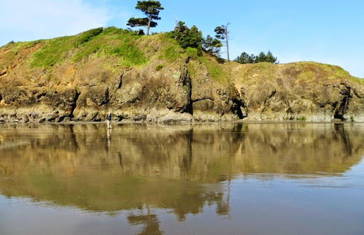
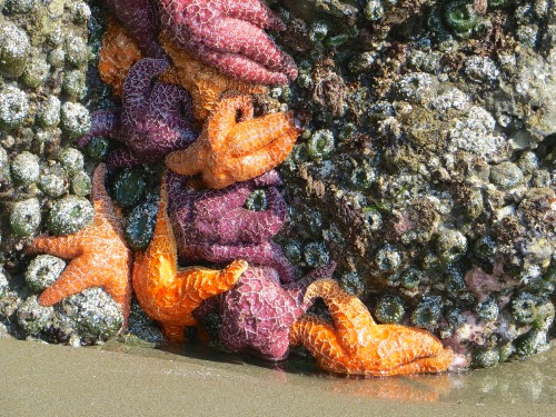
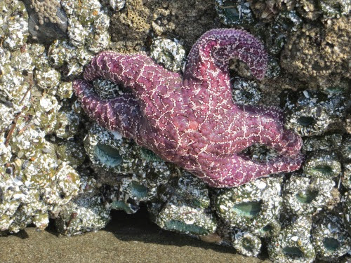
We hike down and as we were beginning to walk through the tunnel, we noticed all the starfish around its base. Bright orange and purple starfish. I’ve probably never seen a starfish that was not in an aquarium. And there were lots of them, all around the sunny side of the base of the rock. Just beautiful.
Walking through the rock is a bit of an anticlimax after that.
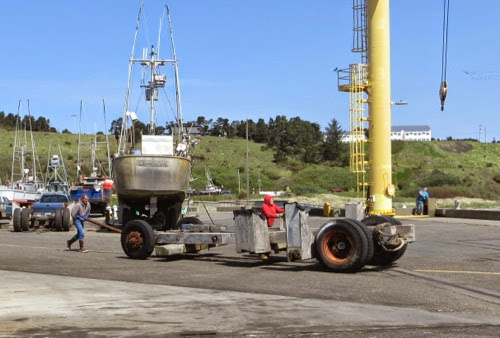
PORT ORFORD’S DOLLY
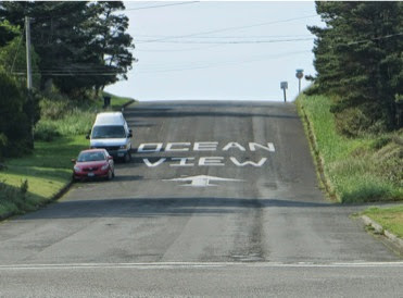
Port Orford wants the tourists to know where to get the best view of the ocean.
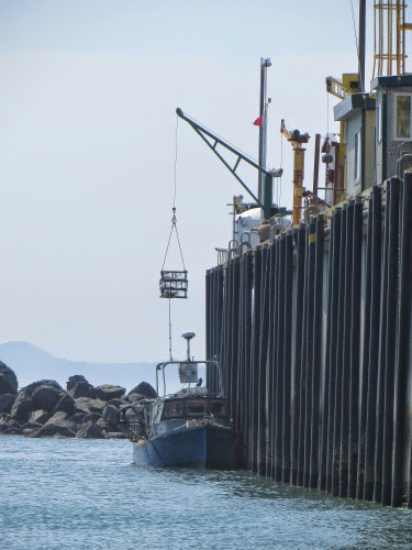
Next we walked over to the harbor of Port Orford which is a working harbor. We didn’t see any recreational boats here, only fishing boats. One reason is that the harbor in PO is not conducive to a marina in the winter and each and every boat has to be lowered into and raised out of the water with a dolly. Every time a boat wants to go out, it and its cradle are rolled to the dolly, the hook is lowered around the boat and it is lowered into the water and the cradle is rolled back into place. The reverse operation happens when the boat returns to the harbor. They have 5 dollies, 35, 25 and 15 tons to raise and lower boats and 2 smaller ones to raise and lower fishing gear and the catch. What an operation.
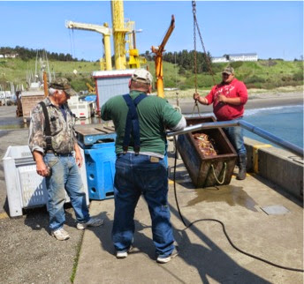
We got there just in time to see a boat being lowered into the water and, while we were there, we got to see about 50 crab pots, a full box of live crabs and finally a fishing boat and its 2 crew being raised. First, the fishing boat pulls alongside the pier and the crab pots and the live crabs are raised to the pier.
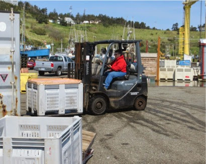
Up on top, the crab pots are fork lifted to this owner’s spot on the pier. The crabs are weighed and then fork lifted into a waiting truck by a woman who’s been here ‘for years.’
Then the boat moved down the pier to a heavier crane and the boat is lifted out of the water. When the boat is up, the owners get off and move their cradle into place.
And their boat is lowered into the cradle and they roll the boat and the cradle back to their spot on the pier until the next time they want to go out.
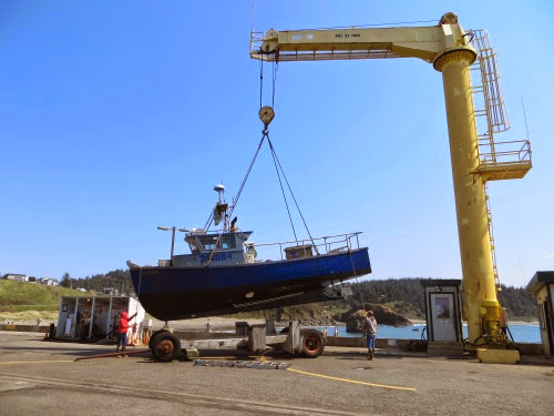
Then the 2, a man and a woman, rolled their cradle into place, their boat was lowered onto it, and they rolled it back to its place in line on the dock. We asked why they were bringing in their crab pots now and they told us that 20’ swells were expected over the weekend which would disburse their crab pots all over the ocean. They pulled them to keep them safe. (This bit of info. gets us up out of bed early Sunday morning to go see these swells.)
Isn’t that something! For some strange reason, this kind of operation intrigues both of us. We’ve never seen this before and it is entirely different from our way of life. Luckily we found each other and can enjoy all this together.
LIFEBOAT STATION
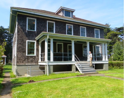
We then drove to the Port Orford Lifeboat Station Museum several miles away. The men who worked here are like policemen, firemen, our armed services and others of this ilk: when things get rough and others are hunkering down, they rush into danger to do their job. When the seas are the roughest, the waves the highest, the winds the strongest, the rains the heaviest, the night the darkest, and someone is in trouble, they rush out into that dark, raging ocean to try to save them.
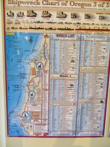
They were called the Coast Guard ‘surfmen’ or ‘Coasties’ and they launched search and rescue missions from the Port Orford headlands from 1934 to 1970. Ship owners and sailors had been asking for a lifeboat station since the 1880’s because many ships had been lost along this section of rocky coast with dangerous currents and high winds. Here is one chart 3 out of 5 showing the wrecks along the shore. And, this is only one chart out of 5: there were a lot of wrecks. It’s a long sad list when you consider all the lives that were lost.
But, the process was slow: the station was authorized in 1891, land was bought in 1906 but the plans for the station were lost in the San Francisco earthquake, and finally, in 1934 it was built, 45 years after it was authorized. There were 13 crew members, an officer in charge, 2 motor lifeboats and 2 pulling lifeboats.
Now, the crew quarters and the 37’ tall observatory lived in the station on a cliff 300’ above where the lifeboats were kept.
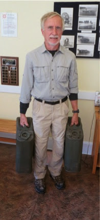
When they saw a distress signal, they whipped into action but first they each had to carry 2 5-gallon (about 40 lbs of gas) jerry cans of fuel down the 530 steps to the boats until the fuel tanks were filled. This is a heavy task in the best of times, extremely difficult when it was rainy and windy.
During its years of operation, this lifeboat station rescued many, including some casualties of Japanese submarine attacks in WWII. But, when helicopters and faster lifeboats cut the need for lots of lifeboat stations, this station was decommissioned in 1970. It was bought by the Port Orford Heritage Society which restored the building and opened a museum.
Here’s where they kept the actual lifeboats down the cliff on the water level. The steps are mostly gone, but you can see the piers on which the lifeboats were kept and a wall for protection. It’s a ways down, especially in a howling, rainy gale carrying gear and jerry cans.

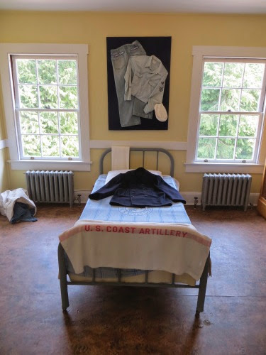
In the museum in the station are all sorts of objects depicting the life of a coastie. There are also quite a few items of life in those times.
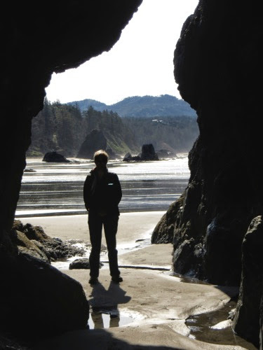
Nice museum with rooms devoted to the lifeboat station, WWII, logging in the area, history of the area, rescues at sea by the lifeboat station, etc. There is also a trail around the head that the station is on - and we took that, natch. On this trail we could see the observatory tower site but the tower itself has been taken down. Beautiful views all around but I kept imagining what the look-outs saw as they combed the sea for distress signals.
No comments:
Post a Comment