
"In the American Southwest, I began a lifelong love affair with a pile of rock." Edward Abbey
There are hundreds of hiking rails in Arizona, some trails have names that make you want to drive 90 miles to hike them: Highline Trail, Tanque Verde Trail, Horton Springs Trail. Others have names that, maybe, the trail makers should have it through just a wee bit harder: Hangman’s Trail, Skull Mesa Trail, Rattlesnake Peak, Military Sinkhole. ‘Military Sinkhole’? Who would drive 90 miles to hike a trail called Military Sinkhole? Yep, you guessed it - Gary and I would. Well, actually, we drove 60 miles to spend a few days in Payson and 30 more to hike this trail which I had read was a nice trail to the top of the Mogollon Rim with vistas across several mountain ranges.
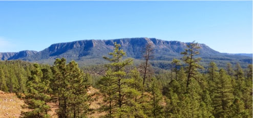
Now, the Mogollon Rim is a 2,000 foot escarpment, which forms the southern edge of the Colorado Plateau. It is about 2000’ - 3000’ above the valley below and 200 miles long extending from the Arizona / New Mexico border to Yavapai County. It was named after Don Juan Ignacio Flores Mogollón, the Spanish Governor of New Mexico from 1712 to 1715. But, why is a geologic formation in AZ named after a governor of New Mexico? Don’t ask me, I just hike. No, actually I do know, Arizona used to be part of New Mexico.
Payson, at 4200’, is a tourist town 60 miles north of the Phoenix area, just below the Rim, where people who live in the Phoenix area escape the heat in the summer since it is about 3000’ higher and 20 degrees cooler than they are. Here one can find huge Ponderosa forests with trails winding through them, lakes with fishing and boating and blue skies rather than the smoggy skies of the valley. However, Payson is also filled with condos, cabins, campgrounds and lots of restaurants, antique shops, gift shops and other shoppes. A typical tourist town. But it also has a neat museum, a natural wonder, a famous author and lots of trails. So, Gary and I planned a 2-day jaunt to Payson: hike and a fish hatchery on Thursday, museum and natural wonder on Friday and home again, home again, jiggity jog.
We started early, found the trailhead, I took a picture of the goal and we took off.
Now, if you want a dirt trail covered with pine needles and fallen leaves, winding through stands of Ponderosa pine with ever improving vistas across the valley to ranges of mountains, this is the trail for you.
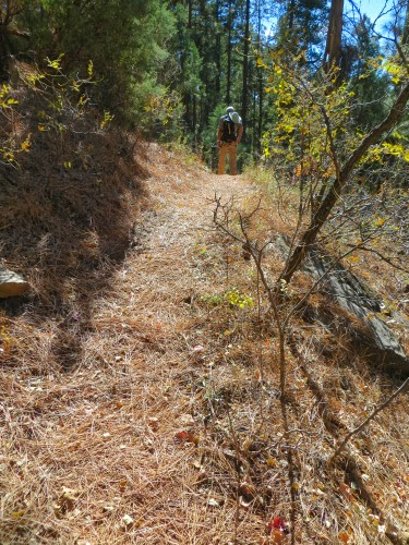
On the other hand, if you want a wilderness experience with solitude to enjoy the songs of birds, the chatter of grey squirrels and the hum of the wind through the pine boughs, try another trail. So, there you have it, the pros and the cons of this trail. This trail parallels a heavily-used 4-lane highway, filled with sand trucks with diesel motors laboring up it to the top of the Rim and others with their jake brakes on laboring down it to Payson. I don’t care which direction they’re going, they are loud, and they seemed to always be in pairs which doubled the noise.
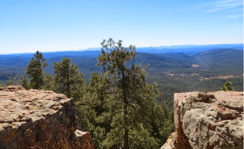
But, the goal was to climb to the top of the Rim and get the views across the multitude of mountain ranges. Thus, the trail itself is enjoyable, winding around several small canyons and inexorably climbing upward. As we climbed, we could tell when we were nearing the top, we could see more and more rock ledges which formed the ridge line,
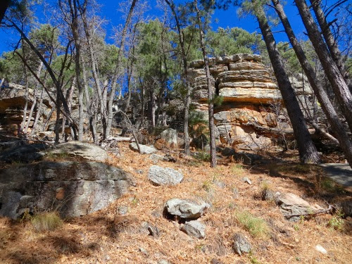
we could see the blue of the sky over these rock ledges, and - we could hear the trucks and cars on the road at the top. Huh? Another road with trucks? Sure enough, we climbed the last few feet and there was a paved road, a parking lot and people enjoying the view that we had climbed to see.
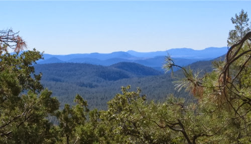
But, what a view! And, what a marvelous rock ledge to sit on for lunch.
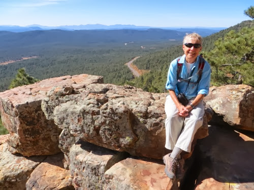
All we could do was sit and look at the layers of blue piling on one another into the distance.
But, we weren’t done hiking, and there was a Rim Vista trail right there running parallel to the road. Why not? We hiked along this for about a mile and were startled to see this.
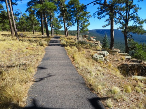
How nice. A 1 - 1/2 mile asphalt trail so those who couldn’t walk could also enjoy the vistas from the Rim. But, it was just a bit jarring to see this where we expected a trail. I’m not used to hiking on asphalt but it sure was easier than a rocky trail. But we had more to do and turned around to retrace our hike down to our car.
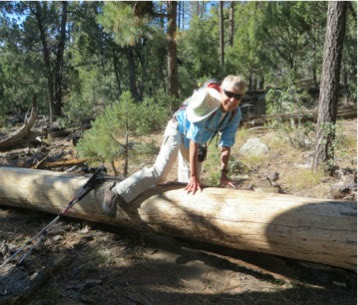
Note the two pictures here to show our different hiking styles. Gary’s style for getting over this log in our path is to jump up with one leg while pushing off with the other. Voila, he lands on top of the log and jumps down. He is of the ‘leap of faith’ type of hiking.
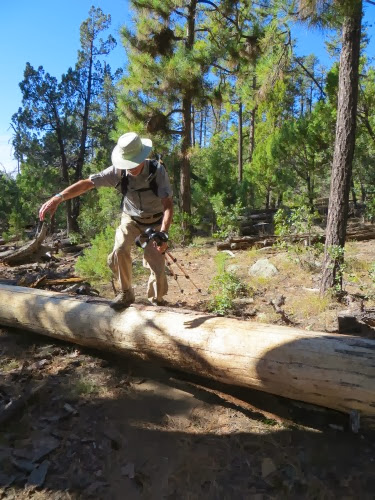
Me, I swing one leg over to touch the ground on the other side, then pull my other leg over the log to meet it. I’m of the ‘terra firma’ type of hiking - always one leg on the ground. Not much jumping, no spring, no leaping from one rock to another. Nope, always a foot on the ground.
Next on our schedule was the Tonto Fish Hatchery a few miles back along the road to Payson. Here we found 9 large rectangular tanks holding trout of several sizes, eating and growing enough to be used to stock the many lakes and rivers around the area.
Feeding time! We had hit the magic moment when the Ranger was tossing feed into the tanks. Here he had just tossed a scoop’s worth into a tank. What a swirling mass of 3 - 4” fish jumping for each morsel. This tank was smooth on the top until he threw the feed in. Then the frenzy began. And, soon, every bit of food was gone.
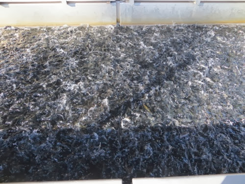
Here they raise mostly Rainbow Trout here, the most popular species of trout, from egg to 6 - 8” and ready to catch. They feed the smallest ones every hour since they are growing fast while they feed those about the size of a man’s finger 3 times a day and those almost ready to stock once a day.
We arrived there at 3:45, they close at 4:00 and we were on our way to check into the motel, shower and head out for dinner. Tomorrow is another busy day.
6.98 1521’
No comments:
Post a Comment