Sunday, September 30, 2012

Gallup, NM - Rest Day, Rest Day, What's That?


InterestingTravelTrailer--2012-09-30-18-55.jpg
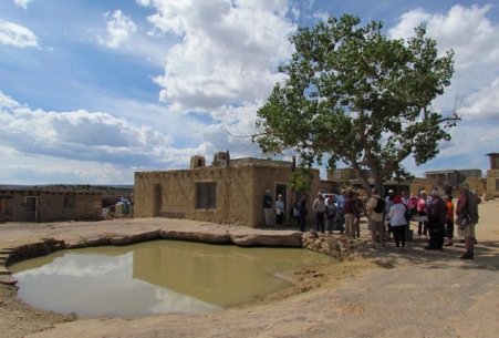
We’re in Gallup, NM today and are staying 2 nights. The town was named after David L. Gallup who was the railroad paymaster. When he arrived with his pay chests, everyone said they were going to ‘Gallup’ and the name stuck. Eventually, it became Northwest New Mexico’s good time town.

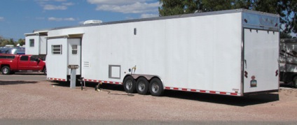
We’re in a nice park which is absolutely full this weekend. In fact they even have several RV’s in a dry camping area off to one side. We are parked in the back row and have this interesting vehicle in front of us. It must be longer than a semi and they must live in the front where the slide is but what do they carry in the back of it?

HikingRedRockStatePark-41-2012-09-30-18-55.jpg
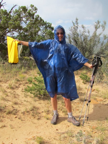
Today began as a rest day. We’ve either been rolling on down the road or museuming or hiking since the day we started, Friday, September 21. Today we’re going to rest, do laundry, do bookwork, anything but something. Breakfast, coffee, and then we were sitting when we decided that we needed to take a walk and why not go to Red Rock park which only 6 miles down the road. Why walk in an RV park when we could hike in a park? Yeah, why not? And thus does the day of rest end.

So, we changed and headed on over to the park, driving on old Hwy 66 as we did. Lots of motels, lots of restaurants, lots of Indian jewelry, pottery, leather works, etc. Billboards lining the highway - on both sides. Yep, this is what I imagined rte 66 would look like. But, it was way more fun than driving Interstate 40 which was about 100’ north from us, enough space for the railroad to wend its way between these two roads. However, there were really not many people on the road itself and many of the businesses were closed - on a Sunday.

We had wanted to eat breakfast out today but all of the possible restaurants that we found online were closed. And, that is typical for Gallup on a Sunday. In fact, most of the shoppes were closed, too - how in the world are they going to sell to the tourists? Dairy Queen was closed - now, how often on a Sunday at 11:00 a.m. could you say that?
HikingRedRockStatePark-22-2012-09-30-18-55.jpg

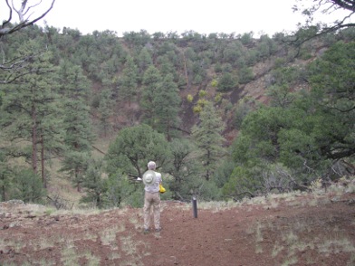
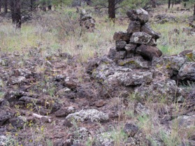
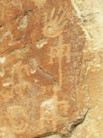
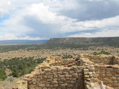
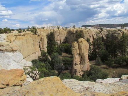
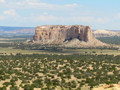
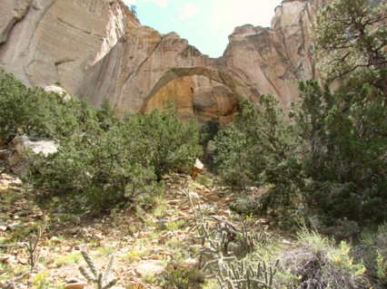
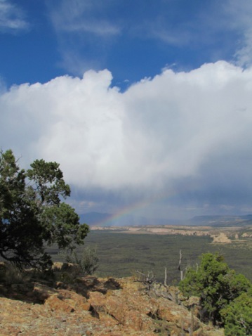
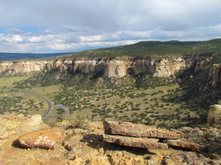
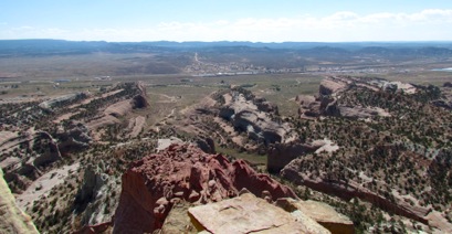
The trail is called the Pyramid Rock Trail, a nice trail with a payoff at the end of a 360 degree view of the Gallup area. We could see for miles and miles. This rocks are striated with about 6 different layers, in all colors from red to pink to grey to white. As we climbed we could see ourselves moving though these layers, through geologic time, we could see the lines between the layers as we stepped from the red layer to the white layer and on up into the pink layer.

HikingRedRockStatePark-9-2012-09-30-18-55.jpg
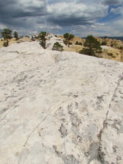
Some of the layers had been worn away so well that we were hiking through extremely find sand, as if it was a sand dune. When the wind came up, Gary counseled ‘keep your mouth closed.’ What does he mean? I’m trying to breathe here. I don’t care how often I hike or how far or how high, I sound like a freight trail coming in to the station, huff, puff, huff, puff, huff puff huff, puff. I sound like I’m dying but I’m still among the living.

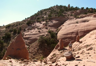
Beautiful views of interesting rock formations all around us.
As we were climbing we noticed a raven swirling through the wind. He was playing with the thermals as he soared around the peak. Then he really got into it when he began to pull his wings in, head downward and then pull up as he neared the rocks. To my human eye, it looked as he were playing with the wind. Maybe it was something else but he did it repeatedly. Must be Jonathan Livingston Raven. Amazing.
HikingRedRockStatePark-33-2012-09-30-18-55.jpg
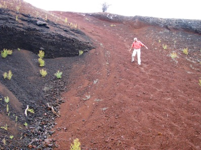
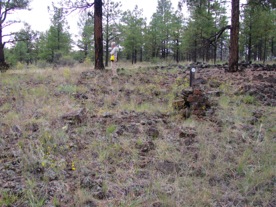
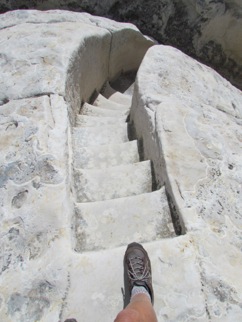
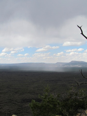
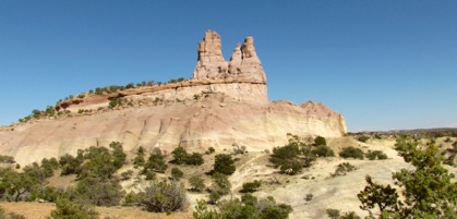
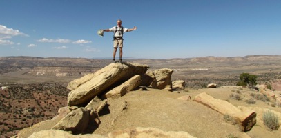
At the top, we took some pictures to memorialize our climb and then began our descent. We had read in my Moon travel guide on New Mexico that there was a trail looping off of this one so we scanned the trail for the junction. When we found it, we were off in a different direction - though this was an unmarked trail and we had no idea where it was, where it went nor if it would end up back where our car was. But, it was early and we had the energy to explore. Besides, when one hikes in the desert, one can usually see where one wants to be, there are not large trees to block the way. Of course, there was the matter of these huge bounders and hills but we still knew where our car was. It’s much easier to get lost in a forest than on the desert.

As we were hiking down we got a phone call from some good friends of ours who also have an RV and were heading back home from a short trip to a cranberry festival in Wisconsin. We chatted for a while and after we said good-bye, she didn’t quite get the phone turned off and we heard her say to her husband ‘they’re hiking’ I’m sure he turned to her and said ‘tell me something new.’ However imagine being out in the wilderness as we were, hiking among the rocks and desert and being able to get a cell phone call. Such is modern life. Heck, I could have probably been able to check the stock market had it been open on a Sunday.
1__%252524%252521%252540%252521__HikingRedRockStatePark-22-2012-09-30-18-55.jpg
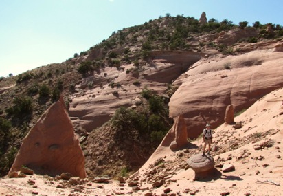
Neat rock formations, neat colors, wonderful layering and a downward trail for the most part. All that I could ask for. We enjoyed it though ‘unmarked’ really describes it and we think we were bushwhacking at times. 

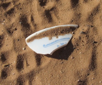
Finally, we got back to the car, where I found this wonderful Indian shard. I’m thinking Corell 1969. Notice the distinct blue pattern.
HikingRedRockStatePark-1-2012-09-30-18-55.jpg
On the trail we had met a woman from the area who told us that we should see El Rancho Hotel and Motel, dating from 1937’s. We scanned the highway as we returned and, when we found it we turned in.
VisitingelRanchoHotel-14-2012-09-30-18-55.jpgVisitingelRanchoHotel-6-2012-09-30-18-55.jpg
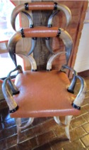
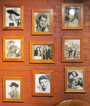
Rustic Western theme in the lobby with a huge stone fireplace, wood paneling, leather and wood furniture tied together with rawhide and decorated with bull horns. It was quite a hotel in its day and hundreds of movie actors and actresses passed through its doors while they were working on movie sets in the area. John Wayne, Burt Lancaster, Lucille Ball, Kirk Douglas, Ronald Reagan, Nancy Wyman, Katherine Hepburn, Spencer Tracy, and many others from the 40’s and 50’s.

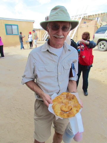
Their signed pictures line the walls and guest rooms are named after them. Tons of atmosphere. And - a restaurant that was calling us. I had been thinking of a hamburg and fries all day and Gary, once he heard the idea, began thinking of a hamburg and fries also. He’s easily influenced. (NOT)
VisitingelRanchoHotel-3-2012-09-30-18-55.jpg
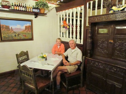
However, once I got seated I ordered the club sandwich with the side salad. Oh, boy. As the Texans would say - I am all hat and no cattle. Gary, on the other hand, followed though and ordered the hamburg and fries.

The meal was yummy and Gary gave me a bit of his sandwich and a few fries. I gave him 1/4 of my club sandwich and we both thought we were in culinary heaven. Well, we’re not that bad. But we did enjoy it. And it was better than the apple blueberry pancakes I was planning. Besides, I won’t have to wash dished tonight.

Back at the RV we showered, relaxed and got ready to move on the morrow.

5.5 1200’

Friday, September 28, 2012

Milan, NM - Volcanoes and the Sweet Smell of Ponderosa Pines

ElMorro-118-2012-09-28-18-59.jpgAfter we had hiked El Morro and see the Inscriptions, we headed back to El Malpais where there are a plethora of volcanoes. And, luckily, it was on the way back to our RV anyway. We stopped at the Ranger Staton where we saw this amazing map which shows the layers of volcanic ash, the volcanoes the ash came from and the relative dates of the eruptions.

Obviously some sections of the park are covered with many layers of ash and cinder cones. On this map you can see 5 distinct layers: brown, tan, grey, light blue and navy.

2 days ago we were on the East side of El Malpais looking out onto this cinder cone lava field. Today we are on the West side at what is called Bandera Crater, which is where the square with the X inside it is. And, actually, we are going to hike up to the huge cone left by the volcano which erupted 115,000 years ago.

The trail itself is pretty straight forward as it winds and twists through the lava strewn fields. We pass by some old caves, deep holes through the many layers of lava over hundreds of thousands of years. We finally reached the actual volcano and below I've pictured Gary standing on the rim of the volcano with the deep crater below him.

HikeElCalderonCinderCone-20-2012-09-28-18-59.jpg
At the top, we turned to return the way we had come in but then spotted a shorter, more fun way to get down, through the red cinder pile. It was like coming down a huge sand dune but, instead of grains of sand, we were coming down marble-sized cinders.

They shifted beneath our feet with each step, sometimes covering our feet entirely but carrying us further and further down the hill. Of course, with each step, we could feel the smaller cinders enter our shoes. But it was a quick way down the slope and much shorter than the way we had circled into the cone via the trail.
HikeElCalderonCinderCone-10-2012-09-28-18-59.jpg
We also took the alternate trail back to the trailhead to make it a loop rather than an in and out. This led us through a forest of ponderosa pines. Back in 1970 a friend and I were hiking in a woods somewhere and I remember that a particular tree smelled like vanilla. I’ve always wondered what that tree was and finally found out - it was the Ponderosa Pine which smells like a vanilla shake. Ummm.
HikeElCalderonCinderCone-2-2012-09-28-18-59.jpg

We also found what are called ‘cinder bombs’ since they were thrown from the heart of the volcano out onto the surrounding land. Here’s Gary crouchng next to one. Imagine looking up  and seeing that aiming for your noggin.

HikeElCalderonCinderCone-5-2012-09-28-18-59.jpg
Back at the trailhead, we thought we’d take a few steps onto the Continental Divide Trail which runs 3100 miles between Mexico and Canada. We’ve hiked many trails, some are an obvious trail through the desert or the woods made wider by all the boots which have trod it. Other trails are scrambles over boulders larger than we are where we have to scramble to the top of one boulder to see the next part of the trail. Other trails are more obscure and need to be marked by cairns. This is certainly one of the latter. It is really not a trail at all, but a walk through cinders, large and small. Good hiking boots are a necessity or you’d twist your ankle when your foot landed wrong on a cinder. The trail is marked by huge pyramid cairns and the rule is, don’t leave one cairn until you have the next one in sight.

TinyBitofContinentalDivideTrail-3-2012-09-28-18-59.jpg
It is a rough trail at this point as you can see from these pictures.
TinyBitofContinentalDivideTrail-5-2012-09-28-18-59.jpg

TinyBitofContinentalDivideTrail-2-2012-09-28-18-59.jpg
Home for dinner.

4   320'

Milan, NM - History or Graffiti?

ElMorro-102-2012-09-28-14-27.jpgSince when does the NPS glorify graffiti and try to preserve it? Well, when it dates from 1605 and comes from such diverse groups as ancient Puebloans, Spanish conquistadors, US Calvary soldiers, Union Pacific surveyors and pioneers. What a hoot - over 2000 signatures, dates, stories, poems and names circling a tall monolithic sandstone rock. Here these travelers found a continual source of water, shade and a spot to rest for the night and a handy surface to record their names and their travels for posterity. A timeless testament to their passage through this spot, maybe a way to pass an idle moment or a chance for immortality. Here we found a bighorn sheep laboriously pecked into the sandstone by by an ancient Indian, a Spanish carving of ‘paso por aqui’, a young pioneer girl’s name carved into the rock and finally a carving by soldiers making a reconnaissance.
And to top it off, literally, is a village on the top of the mesa which, at its height, held approx 1000 - 1500 people in 875 rooms from 1275 - 1350 AD. Only a few of these rooms are excavated but they provide a glimpse into the lives of these early settlers.

The Zuni call it Atsinna, ‘place of writings on the rock’, the Spanish called it El Morro, ‘the headlands’, and the pioneers called it ‘Inscription Rock.’ Officially now it is El Morro National Monument and we found it all fascinating. PLUS it has a neat hike at the top of the Mesa circling a box canyon to the ruins and back down to the Visitor Center. What more could one want in a NPS site? Oh, yeah, a shaded picnic area for lunch after your hike.

ElMorro-108-2012-09-28-14-27.jpg
We arrived about 10:00, toured the displays in the Visitor Center and began our tour of the inscriptions. First we hit the pool of water which is about 12’ deep in the middle but which never runs dry. It was a continual reliable source of water and was on many maps of the area that others took to get through.

There were 4 main groups who used this pool:

        The Early Puebloans: 1100 - 1400 AD who left their pictographs on the stone face

        The Spanish: 1539 - 1774 who were lured by the rumors of great cashes of gold. The first Spanish inscription is that of Governor Juan de Ornate in 1605 on his second trip near the area.

        US Military expeditions: 1846 - 1906.

        Emigrants to the West: 1846 - 1906.

Here you can see the peckings of the early peoples.

ElMorro-100-2012-09-28-14-27.jpg ElMorro-98-2012-09-28-14-27.jpg
Below is the signature of Onate, the very same Onate who conquered the Acoma peoples.
ElMorro-75-2012-09-28-14-27.jpg

After the Mexicans defeated the Spanish and were in turn defeated by the Americans, New Mexico became part of the United States and pioneers began streaming through.

 One was a young woman named America Fancis Baley who,with here sister, Amelia, was part of a wagon trail heading west. Later in the trip, when they got to the Colorado River, 800 Mojave Indians attacked the 60 American pioneers. They killed 9, injured 17 but suffered 87 casualties themselves. The wagon trail returned to St. Louis to wait out the winter but then headed out again. The two sisters eventually made it to California.

ElMorro-104-2012-09-28-14-27.jpg
Here’s the signature of another who stopped here before heading onwards only to be turned back by Indians. Another, Sallie Fox was only 12 years old when she pased through and carved her real name in the rock. Later in the trip she was hit by an arrow during an attack at the Colrado River but survived.

ElMorro-2-2012-09-28-14-27.jpg
In 1855, P (Peachy) Gilmer Breckenridge passed through here with a caravan of 25 camels when the army was experimenting with using camels across the desert instead of mules. He was actually in charge of the camels. When the trip was done, he returned to Virginia to fight with the Confederacy during the Civil War. He was killed during a skirmish in Virginia in 1863.

ElMorro-93-2012-09-28-14-27.jpg
When the railroad was completed in 1881, wagon trains became a thing of the past and few passed this way. In 1906, Theodore Roosevelt made this a National Monument and it became protected by the US Government for all to see.

We circled the bluff searching for signatures, reading the stories of those who signed until we came to the end.
ElMorro-73-2012-09-28-14-27.jpg                        ElMorro-74-2012-09-28-14-27.jpg
However, here is where we started the hike to the top of the mesa where the ancient ruins were.

Huffing and puffing (we’re not quite in hiking shape yet) we made it to the top to find a neat loop trail which took us around the mesa to the ruins.

ElMorro-18-2012-09-28-14-27.jpg
And, when I say a ‘neat’ loop hike, I mean it. At the top you circle along the white sandstone on the top of the mesa, around a box canyon filled with trees.

ElMorro-32-2012-09-28-14-27.jpg
We walked over, between, around and across the white sandstone which forms a top layer on the cliff. We also followed a trail pecked into the sandstone and down the steps carved into the white sandstone rocks by the CCC. A very ingenious trail that kids would love and we adults had a great time with also. I’ve left my foot in the picture to show how small the steps are.

ElMorro-28-2012-09-28-14-27.jpg ElMorro-25-2012-09-28-14-27.jpg
What views the people who lived here had but getting food, water and other supplies to the top of this mesa was an arduous trek. But they did it every day.

PicnicAreaforLunch-2-2012-09-28-14-27.jpg
When we finished the hike, we used the picnic area to eat lunch and then left El Morro and headed back planning to hike in the El Caldrone area of El Malpais area there was an extinct volcano which had erupted 115,000 years ago.
5.5 450’

Thursday, September 27, 2012

Milan, NM - Sky City

Today our adventure is to visit and tour the oldest continually inhabited town in the US, Acoma, the Sky City, founded by the Acoma people (the accent is on the short ‘A’ as in ‘father’) a pueblo people related to the Hopi in AZ. There are other communities which say they are the oldest but this one is still inhabited.

TouringAcomaSkyCity-26-2012-09-27-19-50.jpg
As we were driving the back roads to the Acoma village, we stopped at an overlook with a tremendous scenic view of the whole valley with the Acoma mesa in the middle, ringed by valley and then by surrounding cliffs. Here we found a vendor family, he was a silversmith while she was a potter. She had examples of her work, her mother’s, her sister’s and several other family members including her 10-year old niece. The Acoma are known for their delicate pottery made with very thin walls and very fine black lines. Many in the Acoma community use commercial brushes but she and her mother use yucca, one strand yucca brushes.

I found the pottery on her table exquisite. She told us that she could take 1 - 2 months to make a pot while her mother could take 3 months because her lines are so fine. Did I see any that I would like to have? You bet, several, and one brick red one in particular. But, do I want to carry a delicate piece of pottery in our rolling home which bounces down the highway? Do I have a place for a piece of pottery in our 8’ x 30’ home? Nope and nope. So, regretfully, we told her that her pottery was exquisite but that we couldn’t buy any and continued on our way.

We switchbacked down the side of the cliff to the valley below and headed towards the mesa in the center where the Acoma village was. You must stop at the Acoma Cultural Center to get your tickets and board the bus for the village. You cannot tour on your own. Our group boarded two buses with Brandon, whose Acoma name is Turtle, and up we went. Here we found a community of about 70 acres built almost entirely of sun-bleached adobe. Although there are about 300 homes here, only about 50 people live on this mesa year round since there is no running water and no electricity. But the town fills to overflowing on feast days and especially on September 2, when they celebrate the feast of St. Esteban.
TouringAcomaSkyCity-66-2012-09-27-19-50.jpg

The 2 buses curled their way up the 370’ to the village at the top. Originally the Acomans climbed to the top of the mesa using hand and foot holds. The road we traveled wasn’t built until the late 1900’s.

After we had left the bus, Brandon gave us some general information about his people. I got out my notebook to take notes and was told that no notes could be taken. So, being the good doobie that I am, I quickly shut my notebook and put my pencil away. I got back at Brandon later when he apologized to me. I told him that I would have written down the name of the band he sings with - but I couldn’t take notes. Too bad. He laughed.

Interestingly, women own all of the homes on the mesa and everything in them. They also own the cars, etc. After the marriage, the husband has 4 years to build his wife a home. After that it is hers. If there is a divorce, the husband walks away with the clothes on his back. Of course, the divorce rate is fairly low. Then, the inheritance goes to the youngest daughter.

TouringAcomaSkyCity-48-2012-09-27-19-50.jpg
Much of what Brandon told us was the history of the Acoma people. And, of course, much of this had to do with the Spanish. The largest building in the village is the Church of San Esteban del Rey, built by the Acoma people - under the direction of the priest and the weapons of the Spanish conquistadors. The building might be an epitome of Spanish religious architecture, but it is also the epitome of Spanish brutality. The roof beams and the 4 main altar logs were found on Mount Taylor, 11,000’ high and the Acoma men carried these logs back to the village on their shoulders a distance of 30 miles. Since the altar logs were ‘holy’, any Acoma man who dropped them to the ground was killed. The only trail up to the village on the mesa was a hand and foot hold trail. The logs had to be carried up this trail. I’ve got a few pictures of this towards the end of this blog so you can imagine how difficult to carry 40’ logs up it.

TouringAcomaSkyCity-15-2012-09-27-19-50.jpgObviously the Spanish provoked many incidents with the Acoma people and all of the other pueblo people throughout the Southwest. After one such incident, the Acoma retaliated and, after the inevitable Spanish win, the Governor, Don Juan de Onate, found them guilty and every male over the age of 25 had one foot amputated, every one between the ages of 12 and 25 were pressed into slavery and the children were sent away to convents.

On the other hand, they Acoma people had some subtle ways in which they resisted the Spanish. Normally the Puebloan people entered their homes via a ladder though the ceiling. During the Spanish rule, however, they were forced to have doors on the street level so that the Spanish could enter at will. Here in the picture you can see the result of this rule. Since the Acoma people were about 5’ tall, they made the doorway tall enough for them to enter. The Spanish were 5’7 and had wore armor. Obviously, it was difficult for them to enter these doorways. HA!

Eventually, the Spanish retreated in 1680 and the Acoma were left in peace in their Sky City where they have lived since.
TouringAcomaSkyCity-52-2012-09-27-19-50.jpg
Here you can see our tour group standing by the ‘Acoma National Forest.’ This is the only tree on the mesa and the Acomans have laughingly named it a National Forest.

There were many Acoman artists displaying and selling their goods throughout the community. Gary and I need no jewelery but we could use a piece of fry bread. Note the smiley face cut into it.

TouringAcomaSkyCity-7-2012-09-27-19-50.jpgTouringAcomaSkyCity-41-2012-09-27-19-50.jpgThe tour was complete and educational and we all thanked Brandon for his enthusiasm and knowledge. At the end of the tour we had a choice: return to the Cultural Center by bus or climb down to the Cultural Center the way the original Acomans did. Well, actually, not the original way - not using the hand and foot holds. No, they’ve carved steps into the sandstone so it is easier to get up and down. And, guess which choice Gary and I made? You guessed it - we took the older trail and walked down to the Cultural Center. Here’s Gary standing on the steps with his hand in one of the old handholds. Luckily there are steps.

TouringAcomaSkyCity-6-2012-09-27-19-50.jpgWe were joined by a young British woman who worked for her company at Los Alamos as an ‘essential’ employee. She was visiting Acoma with her parents who had come over from England. This trail was made for the Acomans of the 17th Century and not for us large Anglo Saxons of the 21st. It’s also pretty worn and slopes down. But, but, but - it’s better than hand and foot holds. You can see another hand hold near her left hand.

After the tour, we headed back to the RV but we needed some groceries. Yesterday, knowing that we needed to shop and, wanting to shop somewhere else besides Walmart, we had checked an app on our I Phone for nearby grocery stores and found only convenience stores. Then we drove down the main street of Grants which is the main town in this area to see if we could find a grocery story. No, we couldn’t. This area had thrived when the uranium mines were producing but had been almost decimated when they closed. Now all that was left was Walmart. And, that is where we headed on our way home today.
Contests%252526IceCream-1-2012-09-27-19-50.jpg

Contests%252526IceCream-2-2012-09-27-19-50.jpgWhen we had finished and were on our way back to the highway, we saw this sign by a nearby store. Aha, maybe that trip to Walmart was serendipity. Inside we found a liquor store but - there in the middle was the telltale freezer with about 16 different flavors. The sign on the front window said ‘Blue Bunny’ from Iowa but the ice cream was Blue Belle from Texas. I had the Southern blackberry shortbread while Gary had the - of course - mint chocolate chip. Did that ever hit the spot. Looks like a salad tonight for dinner for me. But, as the old saying goes: life is short, eat dessert first. Which I did.

As we were sitting in our car savoring our ice cream I noted the Bud sign ahead of us. What is it about ‘for life’ that Budweiser does not understand? Only ’Up to 50 years’?

Wednesday, September 26, 2012

Milan, NM - Got a Poncho?

Another day, another National Monument. We’ve always figured that the National Park system Parks, Monuments, Battlefields, etc., are pretty special so we try to see them when we’re in the area. Today, we’re in Milan, NM, right out side of Grants, NM, east of Albuquerque (first I had to learn how to spell that). Mr. Milan, (mee LON - pronounced like the city in Italy) was a citizen of Grants but, when he got irritated with the City Council and its politics, he moved out side of town and started his own village, Milan. Actually, my father-in-law’s name is Milan (pronounced MY lan) and we’ve taken a picture of the Milan water tower to send to him.

We’re perfectly located to visit 2 National Memorials: El Malpais (El Mal pay EES’’) and El Morro so we’re here for 4 nights. Our campground is good except it is sandwiched between Interstate 40 and the railroad which has a train with 2 sets of rails accommodating at least 4 trains about every 10 minutes. Sometimes, we got a twofer and two trains passed each other going different directions. Whoo-eee. This all sounds like a real problem, right? Wrong - I guess we can sleep through anything and so could every one else in the campground, judging by all the other RV’s here. I might be a light sleeper but train whistles do not affect me. Besides, we were at the other end of the campground. But, we were continually amazed at the number and size of the trains. Must be how we get all of our goods from cars to furniture to clothing - everything made in China and India which unloads on the Pacific coast.

El Malpais means "the badlands", and it was named after the huge valley covered with hardened lava flow from erupting volcanoes and from lava oozing up from the ground. As we drove into town, we could see miles and miles of these rough black lava cinders on either side of the highway. The area also has cinder cones, lava tube systems and huge trenches carved out of the erupting lava flow. The lava fields are pretty treacherous to try to cross although it was an ancient trail for the Puebloans who lived in the area. These lava fields are surrounded on both sides by 500’ sandstone cliffs.

NaturalArch-17-2012-09-26-19-42.jpg
After visiting the Visitor Center, we headed down the highway to the Ventana Arch, the 2nd largest natural arch in New Mexico.. Because it was so close to the other rocks, it was difficult to see that it was an arch but it was a wide span and a beautiful arch.

Our main goal for the day was the Rim Trail which began 5 miles south of the arch and, when we had completed it and come 4 miles, we stood at the top of the sandstone cliffs and could see the arch across a small valley. I’m sure the trail wasn’t as treacherous nor as lava-strewn as the lava beds below but it had moments where the trail was literally covered with hard, rough, sharp-edged lava rocks. On the other hand, it was a fun trail with great views across the lava beds to the sandstone cliffs on the other side.

HikeatRangerStation-1-2012-09-26-19-42.jpgHere’s another view we had. I’m no snake expert and neither Gary nor I thought this was ominous when this little critter crossed our path. we merely stepped over it. Well, maybe I leapt over it rather than stepped. Actually, I’m thinking this was a bull snake, fairly harmless and they eat lots of rodents. One of those creatures like bats that people would rather not be in the same room with but which do a world of good for us.

After an hour or so, we could look across the lava beds and see the - RAIN sweeping across the valley. Oops. Sure enough, the 20% rain chances turned into 100%. It wasn’t all virga rain - some of it was real rain. Here’s a picture of the rain rolling across the lava beds. We’re looking at the blue sky with the white fluffy clouds, hoping that this little rain shower will go either to our right or to our left.
RimTrailHike-33-2012-09-26-19-42.jpg
But - we were prepared - look at this beauty. I never said that I had to be beautiful on the trail. I’ll bet that none of you would claim this person as a friend. Looks pretty strange to me. And, note that I’ve got a shadow. The shower passed so quickly that, by the time I got the poncho on, it was past.
RimTrailHike-20-2012-09-26-19-42.jpg
But we could see more of it heading our way. But, we were so close that we had to continue to the end.

And, there it was, the end with the view across the valley of the arch.

We didn’t stay long to celebrate our hike because we knew were only 1/2 way done - we had to get back. And, now we could hear the thunder rumbling across the sky. But we also had a great view of this rainbow.
RimTrailHike-3-2012-09-26-19-42.jpg
RimTrailHike-17-2012-09-26-19-42.jpgBut, what’s that ahead of us? Why, it’s another couple coming our way, in sneakers with only one bottle of water and no other gear. We found out that they had parked by us and had taken the same trail but, because they had no map, had no clue about where the trail went, where it ended, how long it was nor that it was not a loop but an out and back trail. Oops. Now, remember, it is thundering mightily off to our right and we have every expectation of more rain. Gary and I are hurrying back to our car hoping we can beat the rain. And - we meet this couple coming out. What were they thinking?

Well, this would not be the first time we met people heading out onto the trail with a real threat of rain. And, it will probably not be the last. When we told them that the trail was an out and back and that the arch was another 3/4 mile at least, they made a quick 180 degrees and joined us on our way back. Now, we’re not ambling along, we were moving quickly but they were walkers also and kept up with us. I’m also thinking that they didn’t want to be out there alone, with out water, without a map and without a clue. And they thought we did. Ha, ha, ha.

We all made it back to the car and they headed back to Albuquerque where they were staying and we headed back to our RV.

9.5 1030’

Monday, September 24, 2012

Liberal, KS to Tucumcari, NM - Flying Through Kansas


Mid-AmericaAirMuseum-1-2012-09-24-10-53.jpg

Since our goal yesterday was to visit the Mid American Air Museum and we were still in its parking lot, we decided to visit it before we headed on down the road to Tucumcari, NM. This museum is the 5th largest air museum in the country, one that surpasses it is also in Kansas. Which brings up one of the more amazing facts that I learned today: that Kansas is in the forefront of aviation history. Who knew? Well, I’m sure that many knew but I certainly didn’t.

Did you know that 1/3 of the aircraft produced in the world is made in Kansas?

Did you know that KS trained more airmen during WWII than all the other states combined?

Cessna, Stearman, Beech - recognize these names? If you’re into aircraft you certainly would. All of these men started in Kansas in a partnership. Eventually they all founded their own company: Cessna, Beech and Boeing.

The Museum certainly had a lot of planes and one of them was the type of plane that Gary worked on while in the Navy.

But we wanted to travel today, on to Gallup, NM so we left the museum and headed on down the highway.