
Another day, another National Monument. We’ve always figured that the National Park system Parks, Monuments, Battlefields, etc., are pretty special so we try to see them when we’re in the area. Today, we’re in Milan, NM, right out side of Grants, NM, east of Albuquerque (first I had to learn how to spell that). Mr. Milan, (mee LON - pronounced like the city in Italy) was a citizen of Grants but, when he got irritated with the City Council and its politics, he moved out side of town and started his own village, Milan. Actually, my father-in-law’s name is Milan (pronounced MY lan) and we’ve taken a picture of the Milan water tower to send to him.
We’re perfectly located to visit 2 National Memorials: El Malpais (El Mal pay EES’’) and El Morro so we’re here for 4 nights. Our campground is good except it is sandwiched between Interstate 40 and the railroad which has a train with 2 sets of rails accommodating at least 4 trains about every 10 minutes. Sometimes, we got a twofer and two trains passed each other going different directions. Whoo-eee. This all sounds like a real problem, right? Wrong - I guess we can sleep through anything and so could every one else in the campground, judging by all the other RV’s here. I might be a light sleeper but train whistles do not affect me. Besides, we were at the other end of the campground. But, we were continually amazed at the number and size of the trains. Must be how we get all of our goods from cars to furniture to clothing - everything made in China and India which unloads on the Pacific coast.
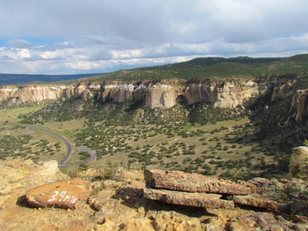
El Malpais means "the badlands", and it was named after the huge valley covered with hardened lava flow from erupting volcanoes and from lava oozing up from the ground. As we drove into town, we could see miles and miles of these rough black lava cinders on either side of the highway. The area also has cinder cones, lava tube systems and huge trenches carved out of the erupting lava flow. The lava fields are pretty treacherous to try to cross although it was an ancient trail for the Puebloans who lived in the area. These lava fields are surrounded on both sides by 500’ sandstone cliffs.
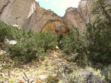
After visiting the Visitor Center, we headed down the highway to the Ventana Arch, the 2nd largest natural arch in New Mexico.. Because it was so close to the other rocks, it was difficult to see that it was an arch but it was a wide span and a beautiful arch.
Our main goal for the day was the Rim Trail which began 5 miles south of the arch and, when we had completed it and come 4 miles, we stood at the top of the sandstone cliffs and could see the arch across a small valley. I’m sure the trail wasn’t as treacherous nor as lava-strewn as the lava beds below but it had moments where the trail was literally covered with hard, rough, sharp-edged lava rocks. On the other hand, it was a fun trail with great views across the lava beds to the sandstone cliffs on the other side.
 Here’s another view we had. I’m no snake expert and neither Gary nor I thought this was ominous when this little critter crossed our path. we merely stepped over it. Well, maybe I leapt over it rather than stepped. Actually, I’m thinking this was a bull snake, fairly harmless and they eat lots of rodents. One of those creatures like bats that people would rather not be in the same room with but which do a world of good for us.
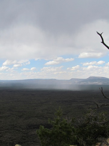
After an hour or so, we could look across the lava beds and see the - RAIN sweeping across the valley. Oops. Sure enough, the 20% rain chances turned into 100%. It wasn’t all virga rain - some of it was real rain. Here’s a picture of the rain rolling across the lava beds. We’re looking at the blue sky with the white fluffy clouds, hoping that this little rain shower will go either to our right or to our left.
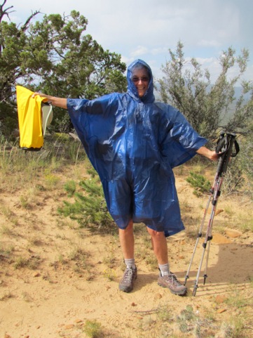
But - we were prepared - look at this beauty. I never said that I had to be beautiful on the trail. I’ll bet that none of you would claim this person as a friend. Looks pretty strange to me. And, note that I’ve got a shadow. The shower passed so quickly that, by the time I got the poncho on, it was past.
But we could see more of it heading our way. But, we were so close that we had to continue to the end.
And, there it was, the end with the view across the valley of the arch.
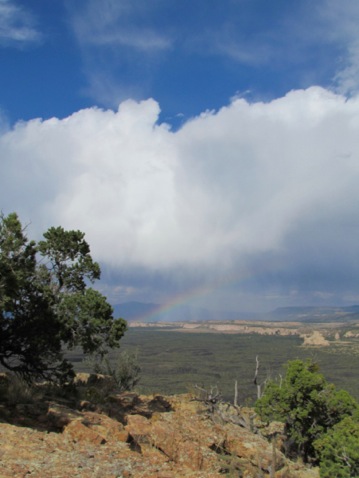
We didn’t stay long to celebrate our hike because we knew were only 1/2 way done - we had to get back. And, now we could hear the thunder rumbling across the sky. But we also had a great view of this rainbow.
We didn’t stay long to celebrate our hike because we knew were only 1/2 way done - we had to get back. And, now we could hear the thunder rumbling across the sky. But we also had a great view of this rainbow.
 But, what’s that ahead of us? Why, it’s another couple coming our way, in sneakers with only one bottle of water and no other gear. We found out that they had parked by us and had taken the same trail but, because they had no map, had no clue about where the trail went, where it ended, how long it was nor that it was not a loop but an out and back trail. Oops. Now, remember, it is thundering mightily off to our right and we have every expectation of more rain. Gary and I are hurrying back to our car hoping we can beat the rain. And - we meet this couple coming out. What were they thinking?
Well, this would not be the first time we met people heading out onto the trail with a real threat of rain. And, it will probably not be the last. When we told them that the trail was an out and back and that the arch was another 3/4 mile at least, they made a quick 180 degrees and joined us on our way back. Now, we’re not ambling along, we were moving quickly but they were walkers also and kept up with us. I’m also thinking that they didn’t want to be out there alone, with out water, without a map and without a clue. And they thought we did. Ha, ha, ha.
We all made it back to the car and they headed back to Albuquerque where they were staying and we headed back to our RV.
9.5 1030’
No comments:
Post a Comment