
Well, it’s 8:45 pm and I’ve just finished dinner and am now headed for the shower. At 8:45? Holy Cow, why so late? Well, it’s been one of those typical Nancy and Gary days - filled to the brim. We awoke at 7:00 in the Walmart parking lot in Fallon, had breakfast, went into Walmart to thank them, get donuts and headed out the door. At the door were some firemen collecting for Muscular Distrophy and, when we got out our money to donate, we realized that we were getting short. Not good for the trip we’re making across mid-Nevada where Wells Fargo ATM’s are as common as snow in Hawaii. We probably won’t hit a Wells ATM till we get closer to Denver. So, onto the IPhone to search out the nearest WF and, sure enough, at the other end of the parking lot, in back of us, is a WF bank. I suppose we could have looked out of the window to see that.
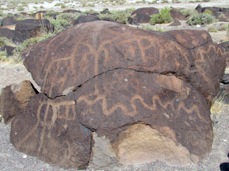
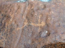
And, we’re on our way. Since we stopped at the Hidden Cave yesterday which is next to the petroglyphs at Grimes Point, today we wanted to see the Grimes Point petroglyphs, walk the loop trail and then the overlook trail. We had thought that there would be many more petroglyphs than we actually saw. Probably because some have been chipped off and are now sitting prettily on someone’s coffee table. Others might have chipped off naturally since the rock was like shale. But the most common reason is that the rocks are re-patinizing. Well, maybe that is not a real word but it does describe the process. Rocks over time develope a patina, usually a darker layer caused by bacteria living on the rock which reacts with manganese to form a dark layer. When the petroglyph is made the artist chips this layer off down to the lighter colored rock itself but, and here is the neat thing, the bacteria again reacts with the manganese to begin forming patina again over the chipped sections. Thus, petroglyphs become fainter as the years go by. The rock art here is from 500 to 8000 years old and many of the petroglyphs have become fainter as new patina forms.
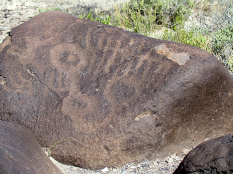
But there were some neat petroglyphs in this section.
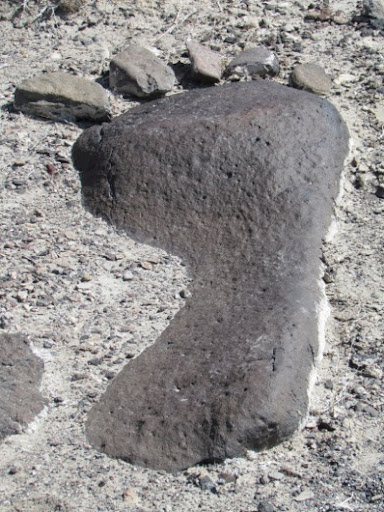
We also found some humorous rock art. Looks like someone who was hiking the trail had a bit ot time on their hands, or, should I say, a bit of time on their feet. Actually, the big toe is as big as Gary’s hiking boot.
Then we hiked the overlook trail to get a view out over the valley to see the setting. Of course, we were not satisfied with just hiking up and back, we wanted a loop so we continued on to come back another way. Well, after some bushwacking when the trail went the wrong way, we found ourselves back on the same trail we had climbed up on and we returned to the car.
Next we stopped at Middlegate, an old stage station on the Butterfield Stage Line and on the Pony Express route. It’s still here and some of it looks as old as the original station. But, look around, a motel, electricity, hot showers, diesel fuel, a wide screen TV showing the Sunday NASCAR races, pool tables, a restaurant serving lunch, and much more. A modern version of the stage stop and it was surrounded by people on bikes, in trucks, touring in cars and 1 RV. Back in 1859, when James Simpson was building routes to the west and naming cuts in the mountains that he took on his journeys, he named them ‘gates’. The name stuck and, when the wagon trains and stage lines came through, they kept that terminology. Thus, this is Middlegate.
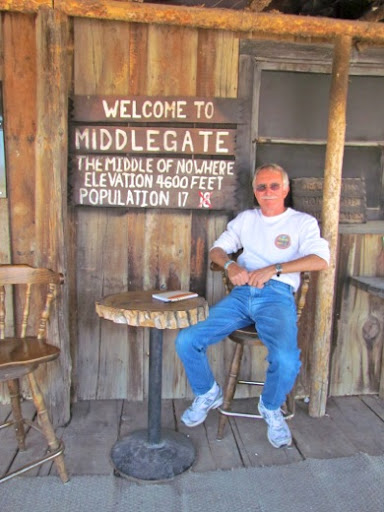
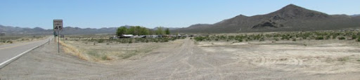
The station continued in business after the Pony Express and the Stage Lines closed as a way station to serve the mines to the south. When it finally closed, most of it was carted off bit by bit by ranchers in the area but a new station was built and is here now. And, they have diesel. Let me backtrack a minute. We have a diesel gauge which does not register correctly. We fill the tank and it says 3/4. Now, we know we can go more than 500 miles on a tank of fuel but, we’ve been doing some hills lately and, thus when it said 1/4 today at Middlegate, we thought we’d better heed the call and fill up. At Middlegate, in the middle of nowhere, with the price of diesel at $4.90? Ouch. Here’s a picture of the scene. The station stop is where the trees are. Believe me when I say that there is not much surrounding it but desert.
And, of course, the fuel gauge snookered us again, we needed only 30 gallons, not the 60 the tank holds. Oh, well, it’s only money - says the cheapest woman this side of Scotland.
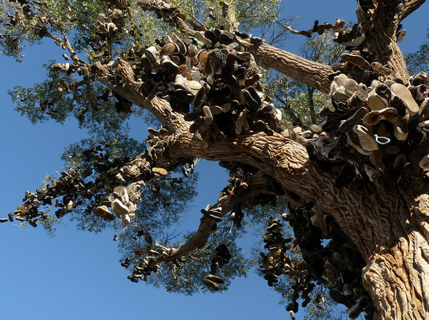
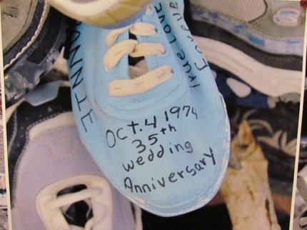
We left Middlegate a bit lighter in the wallet and passed what used to the the Shoe Tree, a 70’ cottonwood where shoes of every size, kind and every color used to hang. And, that’s a sad word ‘used’ because they hang there no more. The legend is that the tradition started in the 1980’s when a young man and his bride to be were heading to Reno to get married. When she had second thoughts, he tossed her shoes up into the tree and drove on. When he got to Middlegate Station, someone talked some sense into him and told him he’d better return, ask her forgiveness and try to win her back. After that, hundreds of travelers crossed the state with old shoes and tossed them up into the tree. Well, they used to. Back in December 31, 2010, some one sawed the tree down. The tried to track the fresh sawdust in the snand but were unsuccessful. Who would do such a thing?
Here’s what the shoe tree used to look like.
Here’s what it looked like in January of 2011.
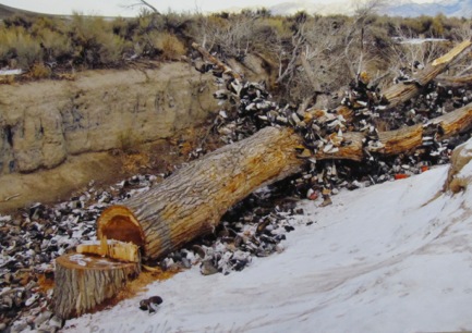
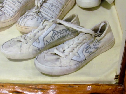
And, here are some of the shoes. After they had held a Memorial Service for the tree, the museum in Fallon took some of the shoes for their display.
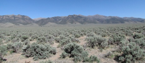
Our next stop was a Pony Express station and, again, it’s in the middle of nowhere. I think that a better placement might have been near a Starbucks, or a Panera, why here? If you look closely, to the right of the single tree (the itty bitty dark dot in front of the mountain in the middle) in the distance is the station. Can’t see it? Neither could we until we got about a mile closer. And that mile took us through a field where cattle were roaming. A white cow watched us all the way up the hill even turning to face us as we trudged by him.
How fast can an e-mail go today? Lightening fast (although out here in Eureka, our e-mail is on extended service and I don’t think ‘lightening fast’ would describe our service now). Well, compare that to the time it took back in the mid-1800’s when mail took months to get from the east coast to the west coast. With the gold rush and the growth of the population in California, quicker communication was needed. There were several attempts but none was as fast as the Pony Express which began in1860 just north of Independence, MO and ended in San Francisco, CA. Stations were built, station masters were hired, horses were bought and equipment was designed but the final piece was the rider. The advertisement was for 'young, skinny, wiry fellow not over eighteen. Must be expert rider willing to risk death daily. Orphans preferred.' They couldn’t weigh more than 120 lbs and had to carry 25 lbs of equipment including a Bible and 20 lbs of mail. When the Pony Express was in full swing it took 10 days for a letter to travel the entire 1800 miles of the route from Independence to SF.
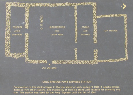
We stopped at the Cold Spring Station, a ways on beyond Middlegate. This is one of the best preserved of the Pony Express stations. Sir Richard Burton, a noted explorer, journeyed through there in1906 and described the station as:
‘a wretched place, half built and wholly unroofed: the four boys, an exceedingly rough set, ate standing and neither paper nor pencil was known amongst them. Our animals found good water in a rivulet from neighboring hills and the promise of plentiful feed, whilst the humans, observing that a beef had been recently killed, supped upon excellent steak. We slept under the haystack and heard the loud howling of the wolves, which are said to be larger in these hills than elsewhere.’
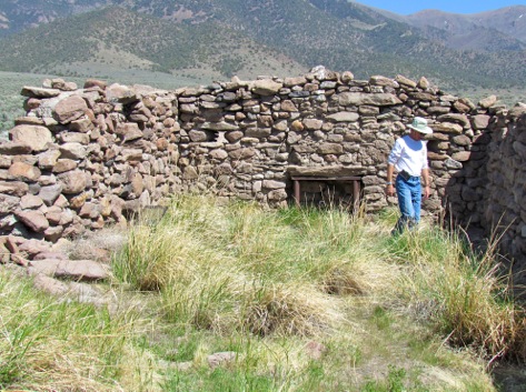
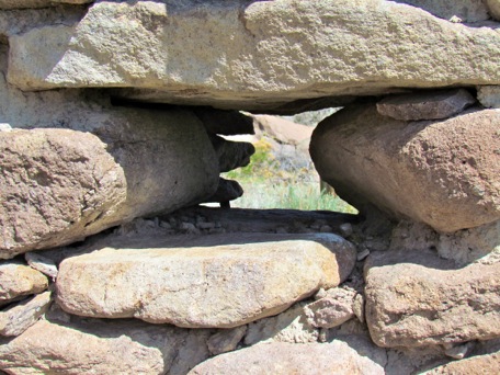
I know we’ve all heard about the Pony Express but it’s legend is so much grander than the 18 months of its existence. It started in 1860 and ended in 1861 when the telegraph was punched through. Didn’t we all think it had lasted much longer than this? And, when we all think of the Pony Express, don’t we all think of the riders? Who ever thinks of the station masters, those men who manned the stations, kept the horses and waited long hours for the riders to come through. The stations were chosen for water so were not always convenient nor comfortable. Horses were cared for well but station masters? Hardly. It wasn’t until after an Indian raid which killed the station master here that the walls were beefed up and a roof was put on the living quarters. Instead of the large windows usually found, here were holes built as gun ports, narrow on the ourtside and wide on the inside for range.
Interestingly, contrary to company policy, when this station was being excavated, a large number of ‘adult’ beverage containers were found. It must have been a lonely life
All together, the company employed 80 to 100 riders and several hundred station workers and lasted only 1 1/2 yrs.
And, like the Pony Express, we were off. Our destination for the day was Eureka, NV, a town of about 600 located 2/3 of the way along Route 50. Gary typed in ‘groceries’ into Google for Eureka, NV and got one response: Rainey’s Market. So, we weren’t expecting much but were pleasantly surprised when we got there and began exploring on Monday.
No comments:
Post a Comment