
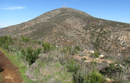
Only 1 day left in San Diego and it’s time for a hike. We’ve been looking up at a nearby mountains for a while and, though another mountain is the ‘highest mountain’ in San Diego, we’re sure that this one is much taller. (We learned later that this mountain is in a suburb of SD so it cannot be the ‘highest mt. in San Diego.) It’s been calling us like an ice cream cone. ‘Hike me, hike me, hike me.’
We did some research on it and found very little - two descriptions of the hike, but the descriptions put the trailhead at different places. We chose the one where we could park in a regional park and not have to park on the side of a residential street.
Big Mistake. That’s where we started wrong. And, it seemed so simple since we could see what we thought was the trail right from the car as we put on our shoes and packs. But, these trails went up Mother Miguel and we wanted to hike San Miguel. Now, without going into all the details, what was supposed to be a relatively simple, follow-the-ridgeline, type of hike turned into a meandering hike which ended up being 3 miles longer and not as simple as we thought.
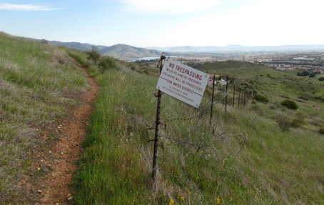
Since we knew approximately where San Miguel was even though we could not see the it, we knew it was through that canyon opening ahead of us so we headed along a wide well-used trail over towards it rather than climbing the peak we had seen. This led us to a barbed wire fence with a metal chained gate with this sign near it.
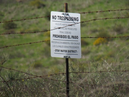
Gary and I looked around to see it there was another trail around the gate but found none and - not wanting to go back to the starting point, we climbed over it. Not our usual modus operandi since we follow all the rules when we hike and scorn those who don’t.
We found ourselves in a wildlife area and on land that used to be part of the local water system. BUT, we followed what was a road through this - we didn’t blaze our own trail. Again, we usually don’t do this. Then we came to the golf course. Oh, good another place where we don’t belong. By this time we could see the ridge-line hike with hikers on it but it was on the other side of the golf course, up a steep slope which again was part of a wildlife preserve. We circled the top of the golf course and scrambled up the slope, hoping that no one saw us - though we were in plain sight of anyone on the course. At the top we found another barb-wire fence with the requisite sign with cut barbed wire laying around. Obviously we were not the first ones through this fence. In fact, look at the trail - looks pretty used, doesn’t it?
Whew. We’re on the trail now. But fences, chained and locked gates, barb wire - what kind of criminals are we? We were certainly outside the law for the first 2 or 3 miles of the hike.
As we climbed, we also found ourselves out of shape. Out of hiking shape that is. And we were in such good shape when we were in Phoenix. We’ve obviously been doing more beach walking that mountain climbing in SD. We could feel the burn in our quads - or, in our out of shape condition, our doubles.
Meanwhile, back on the trail. We found that the trail lived up to its ‘strenuous’ reviews. It went mostly up along scree, slippery smaller rocks: the steeper the trail was, the more slippery the rocks were. Luckily we had our poles. Interesting, the mountains we've climbed that have antennas on top have trails that go straight up, no switchbacks. I wonder why. The hike was lots of fun in parts but the slippery parts - not as much. On the way up, we met several trail runners, some running up the trail and others running down. How can they do that? I”m huffing and puffing going up and fearful of falling on the way down. Figuring they were 1/3 my age made me feel better. Wait til they’re 65, I kept telling myself.
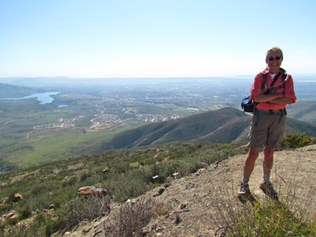
Were the views incredible? You bet. On one side were views of wilderness (and areas that we will hike next time we’re in the area.) On the other side was suburbia.
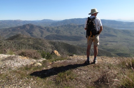
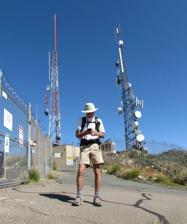
We finally found ourselves at the top of San Miguel, 2500’ up, with all the antennas, in time for lunch and a rest before the hike down. And here is Gary trying to get cell phone reception on his smart phone - all those antennas and no reception. Wouldn’t you know.
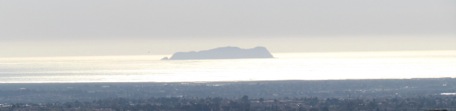
Here’s a view of an island in the Pacific from the top.
Now for the hike down. We obviously couldn’t go back the way we had come. Tempting fate and the law once is chancy but tempting it twice would be a bit too much. But finding the alternate trail was difficult. We finally found it - at the bottom of the ridge-line, only to look up to where the trail went - the 1500’ peak on our right. Ouch. Why did the alternate trail back have to be so far down the mountain?
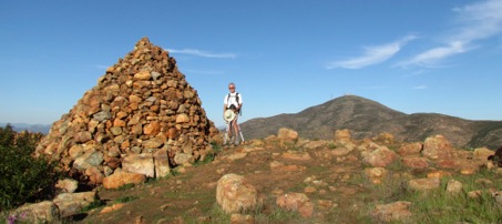
But it is what it is - and we began climbing back up Mother Miguel, knowing that was the way to get back to our car. Hey, but it was not bad (it’s always worse thinking about it) and at the top we found this huge monster cairn. And, by the way, San Miguel is in the background here. Looks pretty easy to climb, right? Nice gentle slope, right? Hmmm. Looks are deceiving. Who knew?
Obviously, lots of people climb this and have some time to spare at the top. As we were climbing up, we heard a coyote howl. Interesting, since we had been looking at lots of coyote scat on the trail. These are very healthy coyotes. We also met a guy hiking up the trail with a 6’ cudgel in his hand - to fend off the coyotes he told us.
Back down this and to the car, a little later and more tired than we had thought.
Here are two hiking lessons for you, free of charge.
- If there is a forest of antennas on the mountain, don’t hike it: it will be steep and there will be no switchbacks.
- Study the trail BEFORE you go. Know where it begins, where it ends and how it gets there.
I have to confess that I am a world class fretter. If there were a Senior Olympic event in fretting, I’d be on the team. I can fret about things that might happen and those things that don’t have an ice cube’s chance in the microwave of happening. I just fret. Drives Gary bananas.
Today I fretted about hiking down the scree on a steep trail. Thought about it on the way up and at the top. Knew I’d have a hard time on the way down or, at least if not hard, that it would take me a long time to negotiate the slope.
Back at the bottom, I wondered what I had fretted about.
But that’s the best thing about fretting - it’s usually better than you’ve fretted. Fretting in advance is often worse thant the actual event.
Next time I see scree on a steep trail - will I fret about hiking down? You betcha. Drives Gary bananas.
No comments:
Post a Comment