
Time for another trail and we’re heading to the McDowell Sonoran Preserve, about 42 miles away towards Phoenix. One of the trails in this area was described rather tongue-in-cheek as one where 'over-perfumed, under-dressed trophy wives with their disengaged, self-absorbed, aloof mountain biker husbands’ congregated. Yep, that’s us. Another was described as a Jeep road straight up to heaven.
Guess which one we chose. You got it - that heavenly Jeep road. As we neared the trailhead we noticed that the subdivisions are crowding in on this area from all sides and it is to the credit of Scottsdale that they keep this preserved nature for all to enjoy. Given what land must sell for in this area, Scottsdale is forgoing quite a bit in taxes to keep this so pristine.
Guess which one we chose. You got it - that heavenly Jeep road. As we neared the trailhead we noticed that the subdivisions are crowding in on this area from all sides and it is to the credit of Scottsdale that they keep this preserved nature for all to enjoy. Given what land must sell for in this area, Scottsdale is forgoing quite a bit in taxes to keep this so pristine.
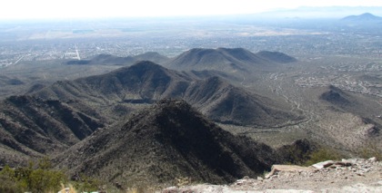
Here’s a view from the top where you can see the encroaching developments on either side of the wilderness mountain. Note also the smog. We have not had a clear view of Phoenix since we got here, there is a continual pall over the city.
There is actually a beautifully bricked bathroom with flush toilets at the trailhead with a large paved parking lot.
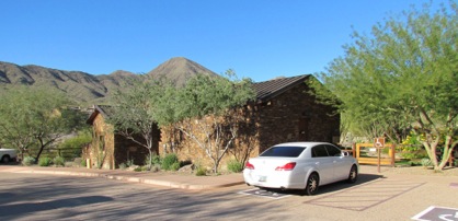
I’m gushing about this because it is so unusual. We get used to dusty, unpaved trailhead parking lots with drafty, vault toilets for most of the trails we take wherever we hike. We surmised, and it was confirmed later by another hiker from the area, that the developer had to put all these amenities in as his price for getting to develop this land. Thank you, Scottsdale. However, the signs warned us that this all was private property and that we had to ‘stay on the sidewalk’ for about 2 blocks to the actual trailhead.
When we arrived there was a group of 20 or so getting ready to hike. The leader was calling off their names and getting the group ready. There was also a group of 5 20-somethings getting out of a compact white car in the handicapped parking area with a handicapped sign on it (probably the grandmother’s car.)
And finally a large family group with 4 adults and about 7 kids. It is Saturday and take-a-number time on the trail. We took off after all of these groups but passed the large hiking group at the fence into the Preserve. Whew.
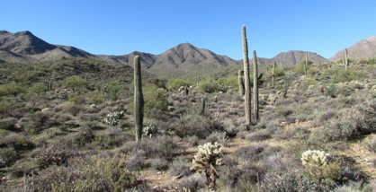
The Sonoran Desert here was lush and beautiful. There was a variety of cacti, a green haze over much of the desert floor and other common desert plants were interspersed among it all. We were enjoying this part of the trail but out of the corners of our eyes, we could see the objective: Thompson Peak in the distance with all the radio and cell phone towers on the top. Here’s the picture though it is difficult to see all the towers on the top of the mountain in the middle, between the two saguaros. But, that’s the goal.
Soon we turned off the trail we were on and hit the Jeep road which would lead to the top. Now the real work began. The road wound slowly but inexorably up until we turned a bend. Then we realized that we were now going to earn our lunch. The trail turned upward as much as I wish the stock market would.
The road builders, not thinking of hikers, just built the trail straight up the hill. I’ve often looked at switchbacks on trails and wondered why I was expending so much energy zig zagging up the hill. Why couldn’t I just head right up? Never again will I disparage switch backs. I will embrace them. This trail was akin to stair climbing - I could have been climbing the 41 stories of the 801 Grand building in Des Moines at an easier angle. if I had fallen on parts of this trail, I’d have rolled all the way to the bottom and landed in the pool of a Scottsdale home.
2 bikers passed us as we were laboring up. We watched them ascend the hill, stopping every now and then as we were but they made it up. We also saw them flying past us on the way down. We could hear their brakes squeaking against their tires as they braked to slow their decent. At this pitch, they will have to replace their brakes tomorrow.
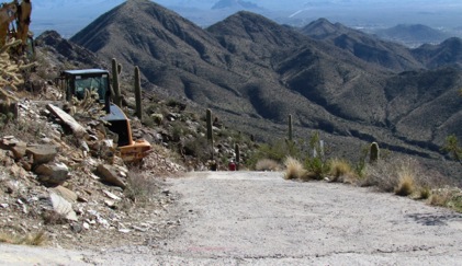
Then the cement started. Cement? On a trail? At this angle? Well, at this pitch, probably the dirt road washed out. Cement held the road better. But, how did they ever get a cement truck up here? And how did they pour cement that stayed on the road and didn’t just goop down the hill? With all those towers at the top of the hill, they obviously need to get up there to maintain them. There also are several buildings at the top for these towers.
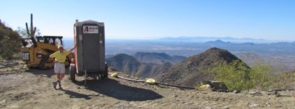
We climbed and rested, climbed and rested, climbed and rested. Then near the top there was a flatter area with a small caterpillar and::
no Starbucks
no Cheesecake Factory
no Cobblestone Creamery
but something much better than all three combined:
a kybo.
I was the first one to ever use it. Interesting. What in the world is this doing at the top of the mountain?
We then began he final ‘sprint’ to the top but were pulled up short by this sign. Hmmm.
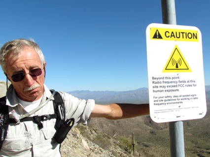
Now, when you’ve had a bit of skin cancer as Gary has, you become much more sensitive to signs like this. So, we regretfully turned around. We hate to stop before we’ve reached the end of the trail or the top of the peak or have completed the loop. However, we did turn around, ruefully, and headed back down to the little area where the bathroom was. We found a great place to sit with a view of the valley and ate our lunch while we thought about it.
Guess what? We decided that we were going to be at the top of the peak for such a short time that we could ignore the sign. So, up we headed. Then we hit the hardest part of the trail, we must have been going up at a 25 degree pitch. It was like climbing up the Empire State Building. Where’s the escalator? Darn that gravity.
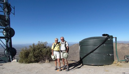
It was hard to stop and rest since standing at such an angle was uncomfortable. We wound our way to the top and finally got there. The view of the surrounding countryside was great. We could see for miles to the surrounding mountain ranges. Below we could see rows of streets as homes are encroaching on the preserve. We could have seen more except for the cell phone towers,
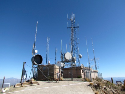
the huge water bladder, the small buildings, the heavy earth moving equipment and the fencing. Kind of ruined the ‘peak’ experience. BUT, and this is a big BUT, we were are the top. We had made it.
Now at the trick is to walk down the hill. At least gravity would help us here. That’s the trick of gravity: it fights us going up trails but helps going down. Sometimes I curse it, sometimes I love it.
Going down was at times harder than climbing up. The trail was so steep that I was sidling down sometimes to keep from losing my footing on loose sand on the cement. Losing my footing would be a catastrophe at this angle - remember that rolling problem.
Leaving aside the steepness of the pitch up Thompson Peak, we enjoyed the trail. And, I’m glad we made it up to the top. Love those bragging rights.
I just hope I can move tomorrow.
No comments:
Post a Comment